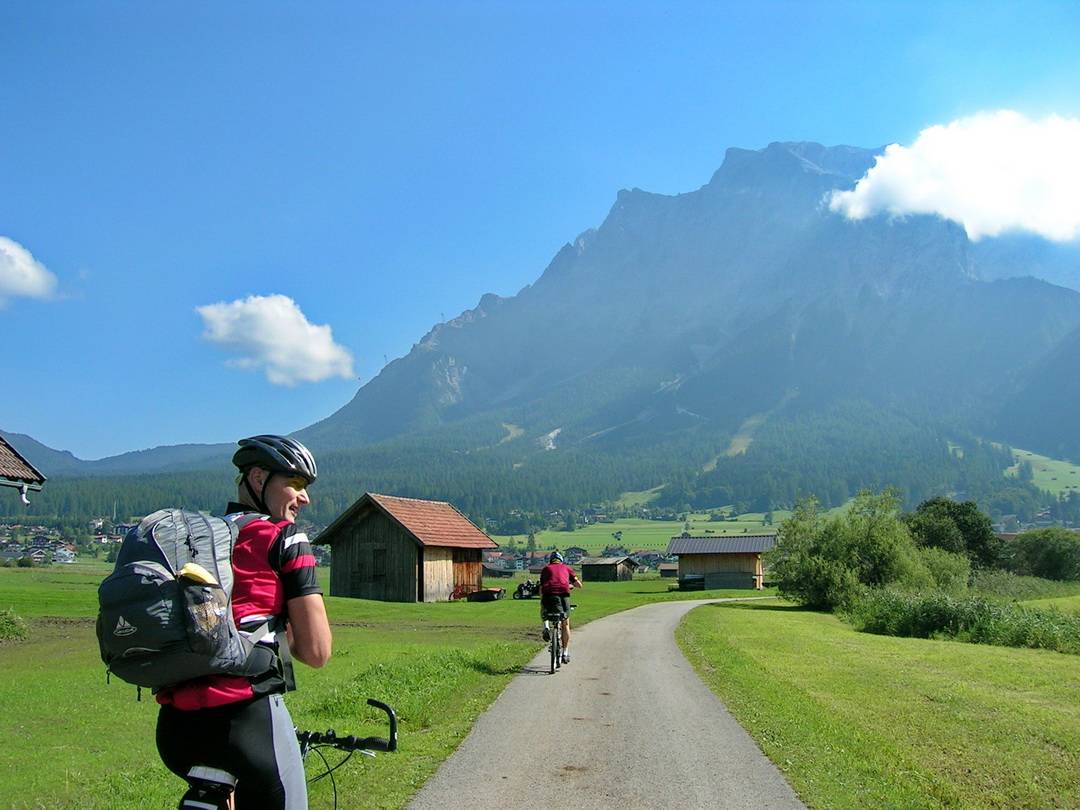
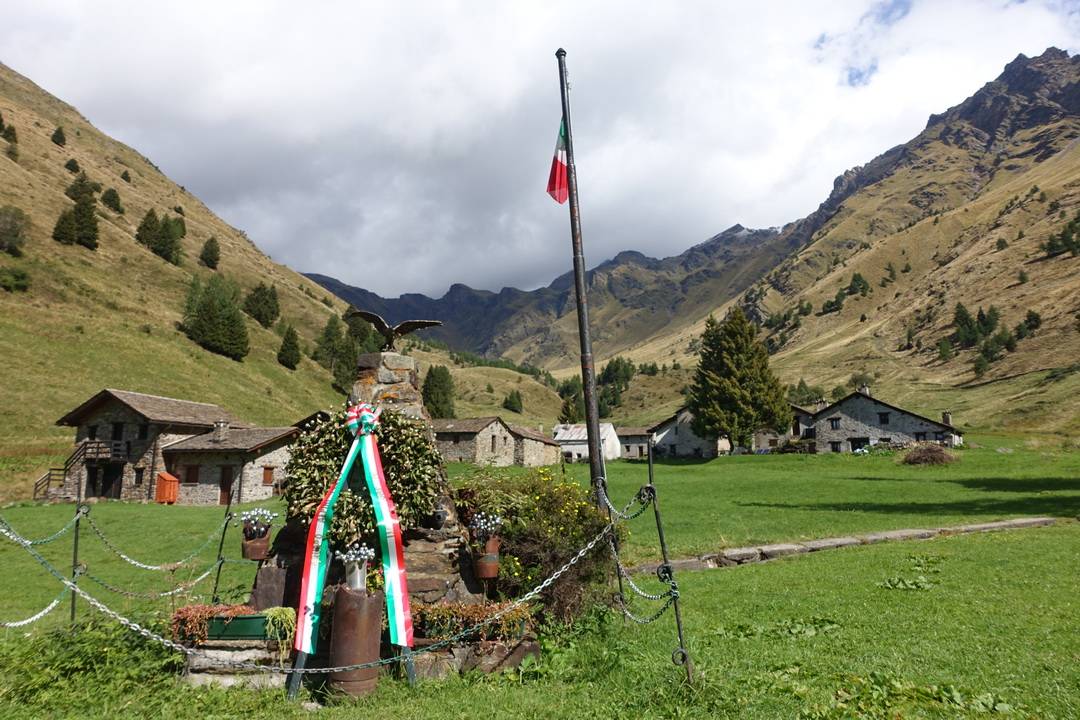
Mit dem Mountainbike über die Alpen
Der Klassiker: Transalp auf der Albrecht-Route
Strecke
Garmisch- Fernpass – Landeck – St. Anton – Verwalltal – Galtür – Ischgl – Fimberpass – Scuol – Pass da Costainas – Münstertal – Val Mora – Passo Verva – Grosio – Val Rezzalo – Passo Gavia – Pezzo – Montozzo-Scharte – Val di Sole – Madonna di Campiglio – Passo Ballino – Gardasee
Länge: ca. 469 km
Höhenmeter: ca. 12.000 hm
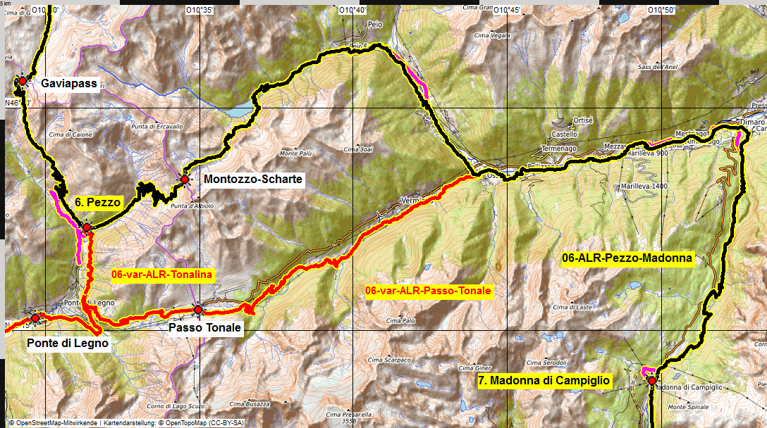
Etappen: 7, Hinweise zu Varianten bei den einzelnen Tagesberichten
Übersichtskarte
- schwarz: aktuelle Albrecht-Route
- rot: aktuelle Varianten der Albrecht-Route
- magenta: Ur-Route

Hinweis
Basis des Tourberichts in Text und Bild ist die Ur-Route, wie ich sie im Jahr 2004 gefahren bin. Seitdem hat sich die Albrecht-Route zu meiner Überraschung und Freude zum Dauerbrenner in der Transalp-Szene entwickelt.
Weiterlesen…
Die grundsätzliche Einteilung der Etappen hat sich bewährt und wurde im Laufe der Jahre nur geringfügig verändert. Ansonsten habe ich immer wieder die Route überprüft und an den Stellen angepasst, wo man sie verbessern kann. Einerseits werden neue Wege gebaut, andererseits habe ich gezielt danach gesucht, Straßenpassagen verschwinden zu lassen, zugunsten von Schotterpisten oder noch besser Trails. Änderungen an der klassischen Route habe ich sehr behutsam vorgenommen. Auf den Übersichtskarten der einzelnen Etappen kann man sich die Unterschiede anschauen. Der Vergleich der Höhenprofile zeigt die Entwicklung der Albrecht-Route. Die Ergebnisse resultieren aus meinen Recherchen zur Version v2 der Albrecht-Route, die von mir im Internet dokumentiert wird.
Die Ergebnisse der laufenden Recherchen sind in diesen Bericht eingeflossen, der den aktuellen Stand dokumentiert.
Übersicht Etappen der Hauptroute mit Hinweisen auf Varianten
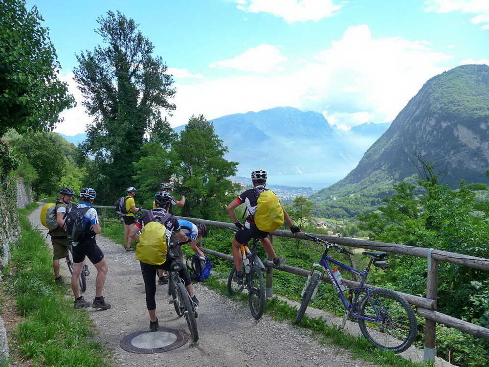
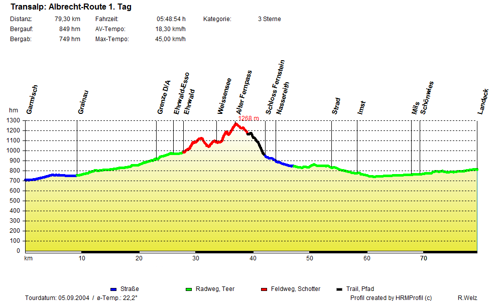
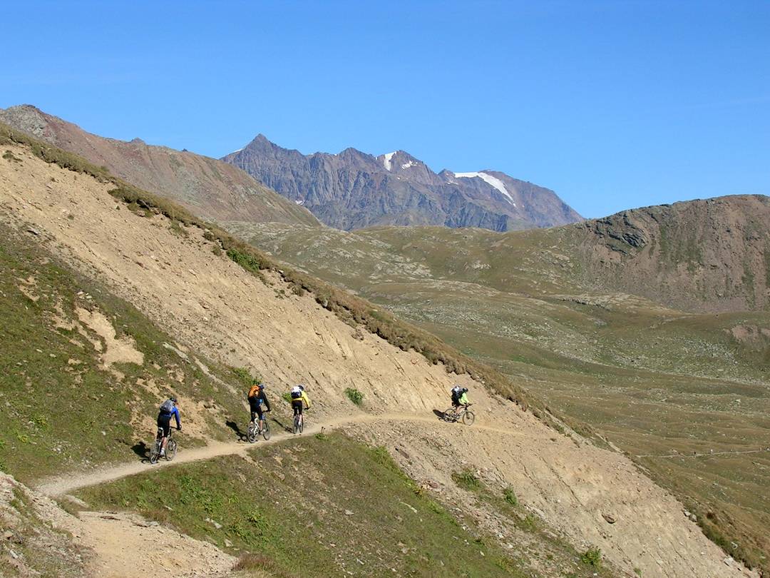
1. Tag: 76,5 km, 907 hm
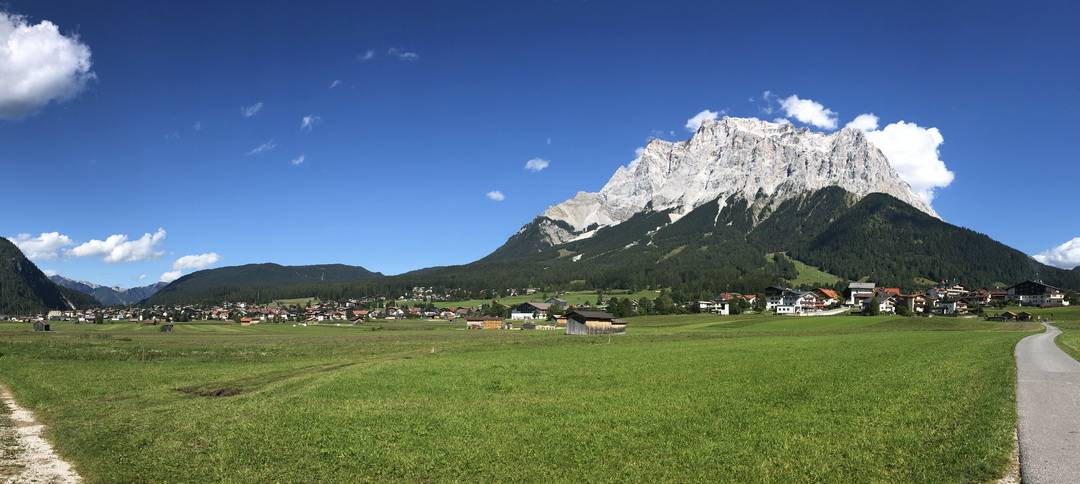
Garmisch-Partenkirchen – Ehrwald – alter Fernpass – Schloss Fernstein – Nassereith – Strad – Imst – Schönwies – Zams – Landeck
– Variante: Biberwier
2. Tag: 78,4 km, 2367 hm
Landeck – St. Anton am Arlberg – Verwalltal – Heilbronner Hütte – Galtür – Ischgl – Fimbertal – Bodenalpe
– Variante: Tobadill – Ischgl
3. Tag: 64,3 km, 2063 hm
Bodenalpe – Fimberpass – Vna – Sent – Scuol – S-charl – Pass da Costainas – Lü – Tschierv
– Variante: St. Maria im Münstertal
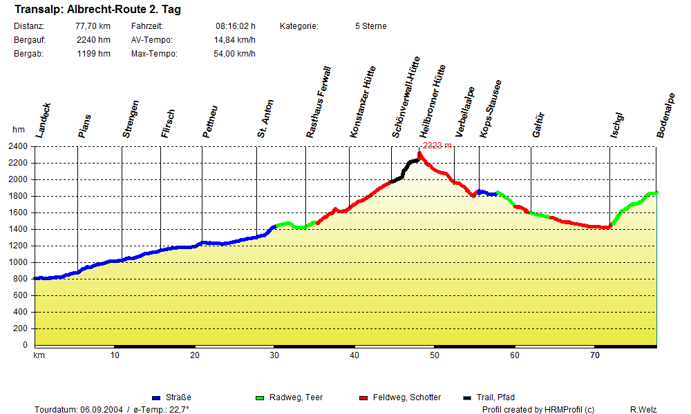
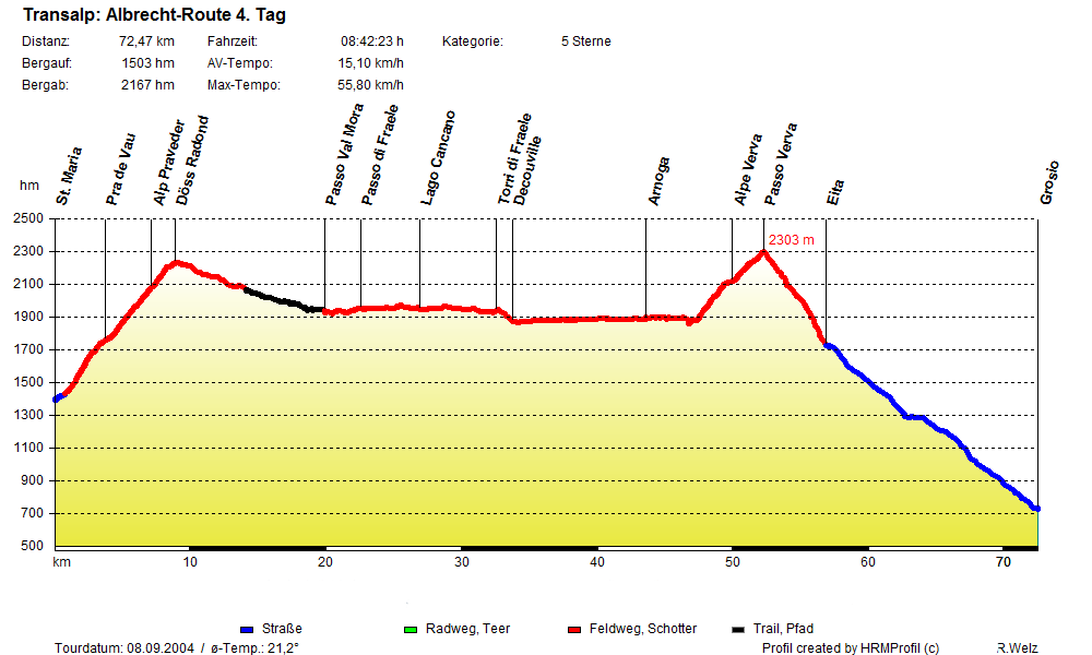
4. Tag: 77,7 km, 1370 hm
Tschierv – Val Mora – Lago Cancano – Torri di Fraele – Arnoga – Passo di Verva – Eita – Grosio
– Variante: Torri di Fraele über Bormio
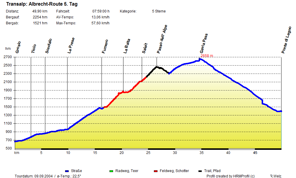
5. Tag: 46,6 km, 2183 hm
Grosio – Le Prese – Fumero – Val di Rezzalo – Passo dell‘ Alpe – Gavia-Pass – Pezzo
– Variante: Passo Foppa/Mortirolo
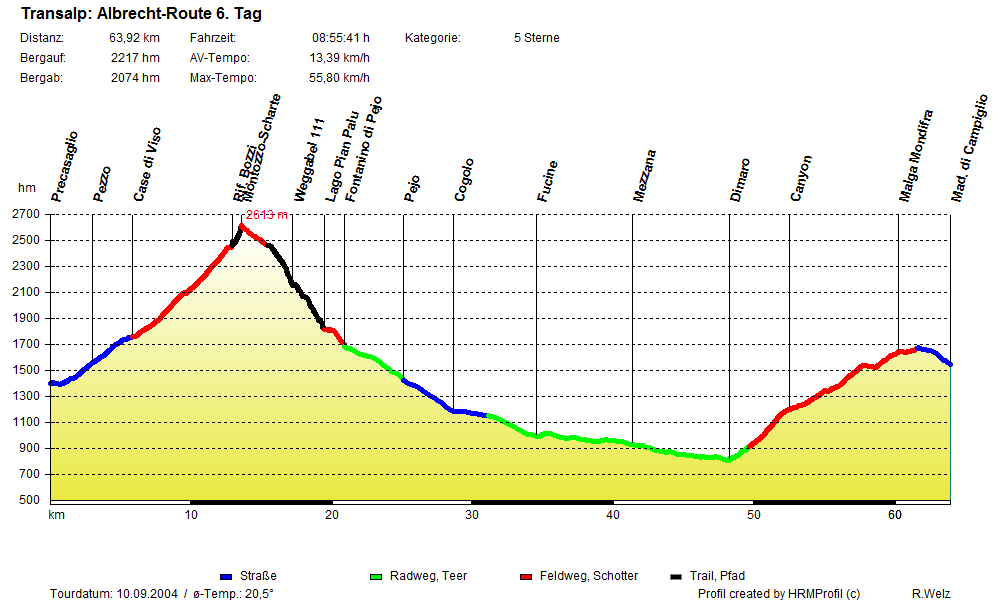
6. Tag: 60,3 km, 2169 hm
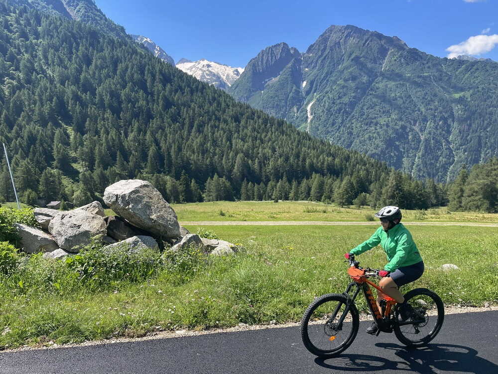
Pezzo – Case di Viso – Montozzo-Scharte – Lago di Pian Palu – Pejo – Fucine – Val di Sole – Dimaro – Madonna di Campiglio
– Variante: Passo Tonale
7. Tag: 67,7 km, 1155 hm
Madonna di Campiglio – Val d’Agola – Passo Bregn de l’Ors – Passo del Gotro – Albergo Brenta – Val d’Algone – Stenico – Ponte Arche – Cure – Passo Ballino – Tennosee – Villa del Monte – Tenno – Deva – Riva – Torbole
– Variante: Sarcatal
Vergleich Höhenprofile der aktuellen Albrecht-Route mit der Ur-Route 2004


Nachfahren der Tour
Folgendes ist im Webshop verfügbar:
- GPS-Tracks
- Kartenscans
- TOPO-Karte für Garmin GPS-Geräte
- Finisher Bikeshirt (auf Anfrage)
Klappentext Transalp Roadbook 1
Eine der beliebtesten Routen über die Alpen ist Andreas Albrechts Tour vom bayrischen Garmisch-Partenkirchen zum Gardasee. Inzwischen sind Tausende von Transalplern seinen Routenvorschlägen gefolgt. Die Albrecht-Routen bieten alles, was das Herz eines echten Mountainbikers höher schlagen lässt: Grandiose Passübergänge, einsame Hochtäler, traumhafte Singletrails und urige Hütten. Dabei muss sich der Mountainbike-Abenteurer durch so wenige Schiebepassagen wie möglich quälen. Aus gutem Grund ist die Albrecht-Route also längst ein Klassiker.
Die Albrecht-Route hat sich zum Dauerbrenner in der Transalp-Szene entwickelt. Trotzdem lässt sie sich immer noch verbessern. Einerseits werden neue Wege gebaut. Andererseits habe ich gezielt danach gesucht, Straßenpassagen verschwinden zu lassen zugunsten von Schotterpisten oder noch besser Trails. Die Ergebnisse resultieren auch aus meinen Recherchen zur Version v2 der Albrecht-Route, die im Internet dokumentiert wird. Dazu gibt es auch Informationen in diesem Buch. Änderungen an der klassischen Route habe ich trotzdem nur sehr behutsam vorgenommen. Diese werden in dieser Neuauflage zusammengefasst und dokumentiert. Der Tourbericht aus der Befahrung im Jahr 2004 bleibt die Grundlage für dieses Buch. Das hat historische Gründe. Er spiegelt den Geist der Albrecht-Route wieder, so wie sie ist.
- im Buchhandel oder versandkostenfrei direkt beim Verlag
- berücksichtigt die aktuelle, verbesserte Streckenführung, mit Hinweisen zur 6-Tage-Variante und v2
- v2-Strecken sind auf den Übersichtskarten markiert
- Änderungen im Vergleich zu alten Auflagen sind hier dokumentiert
- Ebenfalls erhältlich als eBook – mehr Info hier
Andreas Albrecht
Die hier dokumentierten Strecken stammen aus mehreren Komplettbefahrungen und einzelnen Recherchetouren, um die Strecke zu optimieren.
Ur-Route gefahren vom 5.-11. September 2004

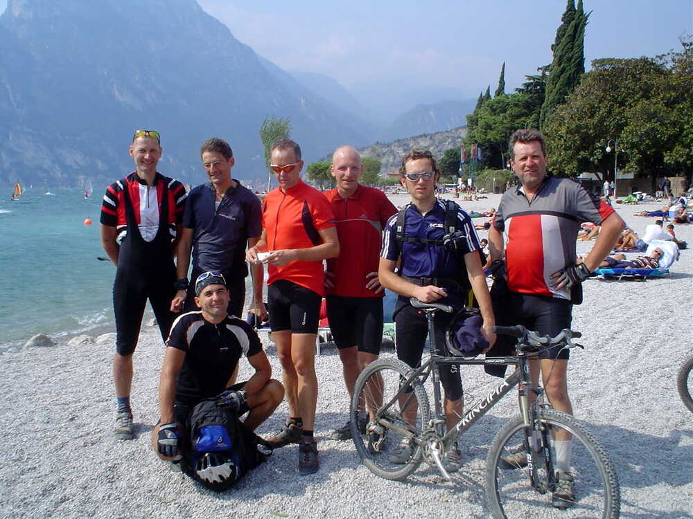
Team Ur-Route v.l.n.r.: HaPe (Ulm – bis 3. Tag), Reiner (Arnstadt), Olaf (Mainz), David (München), Matze (Gräfenroda), Uli (Gelnhausen) †, Andreas (Gotha), Christian (Deggendorf)
Die Bilder stammen von der Original-Befahrung und Erkundungen einzelner Streckenabschnitte. Wenn nicht anders angegeben, unterliegen sie meinem Copyright. Ansonsten ist der Bildautor genannt. Die Bildrechte liegen in diesen Fällen beim Autor, der mir das Recht zur Veröffentlichung erteilt hat.
Prolog
Und am Ende sind es nicht die Jahre in deinem Leben, die zählen. Es ist das Leben in deinen Jahren.
Abraham Lincoln (1809-1865)
Vorbemerkung: Diesen Originalbericht habe ich kurz nach der „Erstbefahrung“ der Albrecht-Route geschrieben. Ich habe ihn soweit als möglich unverändert gelassen. Das hat einerseits historische Gründe, andererseits spiegelt er den Geist der Albrecht-Route, nach meinem Empfinden, gut wider.
Die Fotos stammen überwiegend von der ersten Befahrung. Ich habe sie sparsam ergänzt an den Stellen, wo ich kein Bildmaterial zur Verfügung hatte.
Meine erste Transalp bin ich im Jahre 1994 gefahren. Danach kamen Jahre des Ausprobierens und des Suchens nach einer optimalen Route. Seit dem Jahr 2000 war ich auf der richtigen Fährte, Jahr für Jahr, Tour für Tour. 4 Jahre später, im September 2004, war ich endlich zufrieden.
Weiterlesen…
Alles passt zusammen. Die Strecke, die Truppe, das Wetter – alles spielt mit. 7 Tage Sonnenschein, stahlblauer Himmel und nicht zu heiß, besser kann es gar nicht sein. Ich hatte mich im Vorfeld, mit einem Augenzwinkern, sogar an den Mondphasen orientiert, um den richtigen Zeitpunkt für die Transalp festzulegen. Wir sind am Ende einer Vollmondphase losgefahren. Da ist die Wahrscheinlichkeit am größten, dass es eine Schönwetterphase gibt.
In die Route habe ich alle Highlights einbauen können, die ich in den letzten Jahren befahren habe. Viele Mountainbiker haben seitdem Anregungen aus meinen Tourberichten aufgegriffen und sind verschiedene Varianten meiner Transalps ab Garmisch nachgefahren. Rückmeldungen aus dem Internet und aus den Hotels an den Etappenorten bestätigen mir das immer wieder. Zunächst war ich erstaunt über die Resonanz, dann natürlich erfreut, dass so viele „meine“ Touren nachfahren.
Möglicherweise liegt das an meiner Einstellung zum Mountainbiken in den Alpen. Ich will möglichst viel fahren können, gerade im hochalpinen Bereich. Die Schiebepassagen sollen sich in Grenzen halten. Bikegeschleppe, besonders bergab, finde ich nervig. Das geht offenkundig vielen so. Außerdem habe ich darauf geachtet, für den Fall schlechten Wetters eine alternative Route zu haben, auf der die Transalp weitergehen kann. Zum Glück habe ich diese selten gebraucht.
1. Tag: Fernpass

Strecke: 76,5 km, 907 hm
Garmisch-Partenkirchen – Ehrwald – alter Fernpass – Schloss Fernstein – Nassereith – Strad – Imst – Schönwies – Zams – Landeck
- 5 %: Straße
- 52 %: Radweg, Teer, Nebenstraße mit wenig Verkehr
- 38 %: Feldweg, Schotter
- 5 %: Trail, Pfad
- GPS-Track: 01-ALR-Garmisch-Landeck.gpx
siehe auch Variante Biberwier
- GPS-Track: 01-var-ALR-Biberwier.gpx
Übersichtskarte
- schwarz: aktuelle Albrecht-Route
- rot: aktuelle Varianten der Albrecht-Route
- magenta: Ur-Route

Aktuelles Höhenprofil


Inzwischen könnte ich meine Route aus dem Gedächtnis fahren. Trotzdem habe ich das Roadbook aus drei A4-Seiten und die 18 gescannten Kartenausschnitte dabei, um auf Nummer sicher zu gehen.
Wir sind eine prima Truppe. Schon zu Ostern haben wir uns am Gardasee getroffen und sind gemeinsam Touren gefahren. Menschlich passen wir gut zusammen. Es geht in Garmisch-Partenkirchen los. Wir starten am Parkplatz hinter dem Hauptbahnhof. Es ist ein Sonntag. Das hat den Vorteil, dass wir in der Regel allein auf der Strecke sein werden. Eine Gruppe fährt parallel zu uns. Wie sich am Abend in Landeck herausstellt, nach meinen Roadbooks. Gemächlich setzen wir uns in Richtung Zugspitze in Bewegung.

Diese erste Etappe ist zum Einrollen gut geeignet. Jeder kann seinen Rhythmus finden. Von allen Streckenvarianten ist etwas dabei: grober Schotter, Trail-Passagen, einfache Strecken zum Rollen, bergauf, bergab. Nicht zu viel auf einmal: und immer der Blick auf Wälder, Seen und die Berge der Alpen.

Bei dem herrlichen Altweibersommer ist es ein Genuss für die Sinne und ein wohliges Gefühl auf der Haut, die von der Sonne verwöhnt wird.
Das Panorama ist überwältigend.
Bei diesem warmen Spätsommerwetter kommt ein Stopp am Weißensee wie gerufen.

Danach folgt die einzige größere Herausforderung auf der ersten Etappe, der Anstieg zum alten Fernpass.


Am alten Fernpass sehen wir auf die Autoschlange hinunter, die sich in Richtung Imst quält. Wir sind frei und ungebunden und rauschen die Schotterpiste hinab. Beim Überqueren der Straße müssen wir erst eine Lücke in der unablässig vorüberziehenden Autokarawane abpassen. Die beeindruckendste Passage auf der ersten Etappe ist ohne Zweifel der ausgesetzte Wegabschnitt der uralten „Via Claudia“. Inzwischen ist er als S0-Trail mit einem Hauch von S1 einzustufen. In der Tiefe schimmert der Fernsteinsee zwischen den Bäumen hindurch.

Die eisenbeschlagenen Wagenräder der alten Römerkarren haben sich im Laufe der Jahrhunderte tief ins Gestein gegraben.

Seit einigen Jahren ist der Weg aus seinem Dornröschenschlaf erwacht. Mountainbiker kommen uns entgegen. Sie kämpfen sich den Weg hinauf. Für uns geht es heute fast nur bergab.

Zunächst fahren wir durch Nassereith und danach durch das Gurgltal abwärts in Richtung Inntal. Dabei fühlen wir uns ein wenig an Wege in unseren heimischen Mittelgebirgen erinnert.

Imst passieren wir auf einem schönen Trail, der nach Überquerung der Straße am Hotel Neuner vorbeiführt.
An der neuen Kirche geht es abwärts in Richtung Inn. Am Ufer des Inns erreichen wir den Radweg in Richtung Landeck.

Nach der Stippvisite am Inn halten wir uns nicht lange mit Pausen auf, sondern fahren in flotter Formation weiter. Olaf gibt einen guten Windschatten. Er fährt viel Rennrad. Wir erreichen ein flottes Tempo.

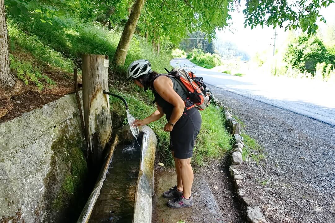
An einer Wasserstelle, kurz vor dem Tagesziel, halten wir an.
Eine Nonne auf einem Fahrrad, die von unserer Spitzengruppe zügig passiert wurde, radelt nach kurzer Zeit entspannt vorbei. So schnell waren wir also doch nicht. Weiter geht’s! In wenigen Minuten sind wir im Hotel „Mozart“ in Landeck. Das hauseigene Schwimmbad und ein Sonnenbad im Garten warten schon auf uns.

Wir sind guter Dinge. Die Wetteraussichten sind hervorragend. Wir freuen uns auf das leckere Abendessen. Seitdem ich hier übernachte, habe ich meine Abendgarderobe ein wenig angepasst. Eine leichte Mikrofaserhose für den Abend ist immer dabei, ebenso wie ein T-Shirt, das nicht zu fahrradmäßig aussieht. Ich mache ein Schwätzchen mit dem Hotel-Chef Thomas Radlbeck, den ich auf einer Messe in Erfurt kennengelernt hatte. Ich freue mich über das Wiedersehen.
Weiterlesen…
Thomas ist so, wie ich viele Österreicher schätzen gelernt habe: verlässlich, professionell und immer herzlich. Er erzählt mir, dass immer mehr Radfahrer sein Hotel frequentieren. Manche seien für eine Story gut. Einer sei einmal mangels trockener Wechselkleidung barfuß und in Unterwäsche zum Abendessen erschienen, was die anderen Anwesenden und vor allem seine Mutter, die Seniorchefin des Hauses, nicht gerade zu Begeisterungsstürmen hinriss. Mit einem Augenzwinkern also hier der Hinweis: Im Hotel „Mozart“ herrscht Ordnung, Krawattenzwang besteht allerdings nicht.
- ab Biberwier leichtere Strecke über Radweg Via Claudia
- verläuft parallel zur Fernpassstraße
- separates Höhenprofil nicht notwendig
- GPS-Track: 01-var-ALR-Biberwier.gpx
1. Tag: 79 km, 849 hm
Garmisch-Partenkirchen – Ehrwald – Fernpass – Schloss Fernstein – Strad – Imst – Landeck
Landeck
- Hotel Mozart: Nähe Bahnhof, Superkomfort, Schwimmbad, super Essen, Telefon: 0043/5442/64 222, abschließbare Radgarage, Reinigungsgerät, Werkstatt und Trockenraum …….. sicher, sauber
Ebenso ein toller Ausgangspunkt für einen Radurlaub über mehrere Tage.
Weiterlesen…
Dazu kann man verschiedene Bus- und Bahntransfers nutzen. Ab einer Nächtigung im Hotel Mozart erhält man die Tirol West Card mit zum Beispiel freien Bustransfers.
Eine weitere Möglichkeit ist die Nutzung von
- Wochenticket Verkehrsverbund Tirol
- Regio-Biking-Wochenkarte Tirol
Damit könnte man zum Beispiel entspannt und stressfrei die 1. Etappe der Albrecht-Route mal ohne schweren Rucksack fahren.
Geht ganz einfach:
- mit Zug von Landeck bis Innsbruck
- mit Zug von Innsbruck über Seefeld nach Garmisch-Partenkirchen
- ggf. sogar mit Zug von Garmisch nach Ehrwald
Habe ich zum Beispiel bei der Überprüfung meiner Strecken in dieser Region genauso gemacht.
Keine Gewähr für die Aktualität und Richtigkeit der Angaben. Hinweise zu Änderungen und Alternativen nehme ich gerne entgegen – siehe Kontakt
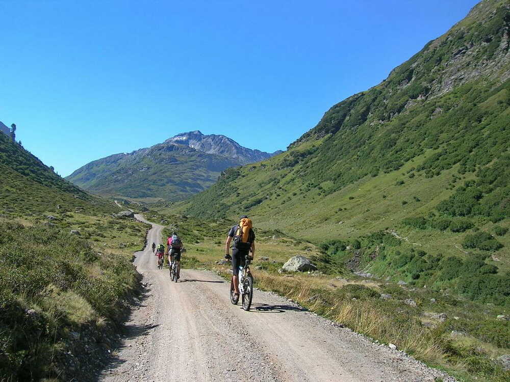
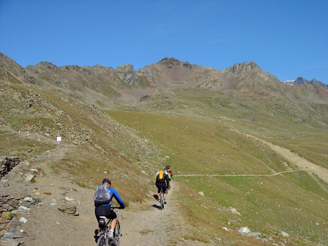
2. Tag: Verwalltal

Strecke: 78,4 km, 2367 hm
Landeck – St. Anton am Arlberg – Verwalltal – Heilbronner Hütte – Galtür – Ischgl – Fimbertal – Bodenalpe
- 10 %: Straße
- 49 %: Radweg, Teer, Nebenstraße mit wenig Verkehr
- 33 %: Feldweg, Schotter
- 8 %: Trail, Pfad
- GPS-Track: 02-ALR-Landeck-Bodenalpe.gpx
siehe auch Variante über Tobadill
- GPS-Track: 02-var-ALR-Tobadill-Ischgl.gpx
Übersichtskarte
- schwarz: aktuelle Albrecht-Route
- rot: aktuelle Varianten der Albrecht-Route
- magenta: Ur-Route

Aktuelles Höhenprofil

Der Gardasee liegt für die anderen gedanklich noch in weiter Ferne. Für mich ist er schon heute nah. Ich gehe im Geiste die Etappen durch und bin mir sicher, dass wir alle Highlights auf der Strecke erleben werden. Für den zweiten Tag hatte ich mir vorgenommen, über St. Anton durch das Verwalltal nach Ischgl zu fahren. Erst einmal heißt es, Strecke zu machen.
In Pians kann man inzwischen die Straße verlassen. Es gibt einen Schotterweg entlang der Sanna. Am Zusammenfluss von Trisanna und Rosanna ist ein Radweg entlang der Rosanna entstanden, der bei Strengen die alte Straße erreicht.
Am Abzweig ins Paznauntal verabschieden sich Uli und HaPe für heute. Sie fahren die kürzere Strecke Richtung Ischgl. Sie wollen es heute ruhig angehen lassen. Uli kennt den Weg aus dem letzten Sommer. Wir werden uns auf der Bodenalpe wiedertreffen. Gegen Mittag sind sie dort und Uli bestätigt mir per SMS die Ankunft.
Ab Flirsch ist es ruhig auf der Strecke.

Wir wechseln auf Nebenwege, die im Winter als Langlaufloipen genutzt werden. In St. Anton am Arlberg ist Gelegenheit, sich zu versorgen. Wir machen insgesamt nur kurze Pausen. Das ist besser für den Körper, der sich auf langandauernde Belastung, aber nicht auf ständige Höchstleistung einstellen muss. Bei dem schönen Wetter ist es kein Problem, mal kurz zu stoppen und eine Banane oder einen Riegel reinzuschieben.
Nach der Ortsdurchfahrt biegen wir am Hotel „Mooserkreuz“ ins Verwalltal ab.

Im Jahr 2000 bin ich hier das erste Mal entlang gefahren. Damals noch mit dem etwas unsicheren Gefühl, was mich auf der Transalp so alles erwarten wird. Heute bin ich ganz entspannt und genieße das langsame Eintauchen in die Gebirgswelt. Das Verwalltal ist ein so genanntes V-Tal, das relativ sanft ansteigend das Überschreiten der Baumgrenze bei rund 2000 Meter für den Normalbiker zum Vergnügen werden lässt.

Die Konstanzer Hütte ist schnell erreicht und passiert. Jetzt schon eine Pause einzulegen, wäre unklug. Danach würde es sich doppelt schwer treten.

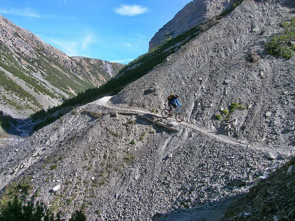
An der Schönverwall-Hütte ist die Schotterpiste zu Ende. Der Trail beginnt. Wir trudeln in kurzen Abständen ein und machen uns auf den Weg bis zu einer Brücke.


Damals begann hier eine Schiebepassage in Richtung Heilbronner Hütte, die mit ein paar Tragepassagen gewürzt war. Das ist nun Geschichte. Hier ein Bild zur Erinnerung.

Update Verwalltal
Ca. 1,5 km nach der Schönverwall-Hütte gibt es ab der Brücke einen neuen Pfad. Dieser führt in Serpentinen auf das Plateau bei den Scheidseen.

Der Trail im Verwalltal lässt sich von der Schönverwall-Hütte bis zur Brücke gut fahren. Danach kann man zumindest gut schieben. Auf dem Hochplateau bei den malerischen Scheidseen lässt es sich auf jeden Fall wieder fahren.


Schließlich meistern alle den Schlussanstieg zur Heilbronner Hütte. Matze und Christian fahrenderweise, die anderen schieben das letzte Steilstück.

Auf der Terrasse knallt die Sonne wie im Hochsommer. Ich esse ein kleines Süppchen, auf mehr habe ich keinen Appetit.
Hinweis: Inzwischen ist die Hütte bei gutem Wetter sehr überlaufen. Ich würde in dem Falle dort keine Rast machen, sondern zum Kops-Stausee abfahren. Die Abfahrt in Richtung Kops-Stausee ist bei diesem herrlichen Wetter ein Traum.

Die Abfahrt ist im oberen Teil steil, weist aber keine technischen Schwierigkeiten auf. Wir lassen es einfach rollen und halten immer wieder kurz an, um die Aussicht auf die Bergketten der Silvretta zu genießen.

Nach der Verbella Alpe muss man aufpassen, um den kurzen, steilen Anstieg zur linken Seite der Schranke nicht zu verpassen. Dieser führt zum wunderschönen Stausee Kops. Nach rechts in Richtung Partenen weiter abwärts zu rollen, ist zwar verführerisch, hilft aber nicht viel weiter. Wir kurbeln ein kurzes steiles Stück nach oben. Ein paar entgegenkommende Wanderer helfen mental ungemein, den mühsamen Gegenanstieg zu bewältigen. Am Stausee halten wir kurz inne. Das Wasser ist durch die eingeschwemmten Sedimente milchig himmelblau.


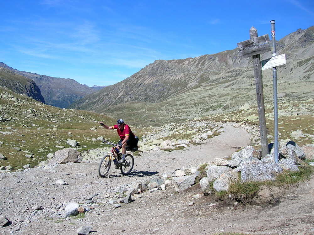
Kurz nach dem Pfad überquert man die Straße in Richtung Gasthaus Zeinisjoch. Man bleibt auf dem Wanderweg. Der mündet direkt auf dem MTB-Weg in Richtung Galtür.

Das Zeinisjoch ist eine Bemerkung wert. Hier spielten sich bis vor wenigen Jahrzehnten oft herzzerreißende Szenen ab. Viele Paznauer Kinder mussten bis in die 1940er Jahre ihre damals bitterarme Heimat den Sommer über verlassen, um sich in Schwaben als Dienstmädchen oder -jungen zu verdingen.
Weiterlesen…
Hier am Joch verabschiedeten sie sich von ihrer Familie und wurden den Schleppern übergeben. Es ist für uns heute kaum mehr vorstellbar, welche Armutsgrenze vor historisch kurzer Zeit durch die Alpen ging. Im damals reichen und mächtigen Deutschland veranlasste dies manche Einwohner, sich zum allgewaltigen Herrscher über das Leben der ihnen anvertrauten bzw. gekauften Seelen aufzuschwingen. Zum Glück ist mit dem Ausbruch des 2. Weltkrieges diese unsägliche Tradition hinweggefegt worden.
Weitere Infos dazu auch auf der Webseite von Montafon Tourismus. Danke an Bernhard Spirkl für die Hinweise.
Nun aber genug des geschichtlichen Exkurses. Wir genießen die rasante Abfahrt in Richtung Galtür, das schnell in Sichtweite gelangt.

Die Lawinenverbauungen sind deutlich zu erkennen. Sie sollen Galtür nach den tragischem Unglück im Jahre 1999 vor Wiederholungen schützen. Man sieht deutlich, dass die Lawinenhänge nicht bewaldet und nicht mit Skiliften erschlossen sind. Es war wohl eher eine Verkettung unglücklicher Umstände, die damals im Winter nach tagelangen Schneefällen den weißen Tod in den jahrhundertealten Ort brachte.

Wir fahren in den Ort ab, um auf dem Radweg neben der Trisanna bergab zu rollen. Inzwischen hat man sich auf die Zunft der radelnden Sommergäste eingestellt. Der Weg ist bestens ausgeschildert. Kurz hinter Galtür, bei einzelnstehenden weißen Häusern (Apart Alexander), folgen wir dem Schotterweg entlang der Trisanna. In der Schlucht rücken die Felswände dicht aneinander. Nach einem verheerenden Hochwasser im August 2005 wurde der Weg neu angelegt und ist seitdem gut ausgebaut. Ischgl ist schnell erreicht.

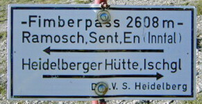
Schließlich erreichen wir oberhalb der Ortslage Ischgl einen Wegabzweig ins Fimbertal. Dort soll heute für uns Endstation sein. Wir kurbeln den zwar steilen, aber durchaus fahrbaren Weg zur Bodenalpe hinauf.

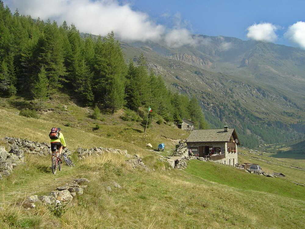
Wir übernachten hier und nicht wie viele andere auf der Heidelberger Hütte. Diese ist oft sehr überlaufen, von Hüttenromantik keine Spur mehr. Dereinst zählte ich dort mehr als 80 Mountainbiker über Nacht, dazu rund 100 Wanderer- und Sangesfreunde der Alpenvereinsektion Heidelberg. Da wurde die alpine Einsamkeit zum Massenerlebnis.
Die Wirtin der Bodenalpe Esma empfängt uns herzlich und wir beziehen unsere Zimmer. Die Zimmer sind sauber und mit Dusche/WC und TV gut ausgestattet. Abendessen und Frühstück sind schmackhaft und reichlich. Fazit: sehr empfehlenswert.

- im Falle schlechten Wetters kurze Strecke nach Ischgl
- am Giggler Tobel meist nasse Trailanteile, ggf. schieben
- ab dem Ort See entlang der Paznaun-Talstraße bis Ischgl mit diversen Umfahrungen
Strecke: 37,9 km, 1514 hm
Landeck – Perfuchs – Perfuchsberg – Tobadill – Vordergiggl – Giggler Tobel – Frodenegg – See – Sesselebene – Kappl – Ebene – Ischgl – Bodenalpe
- 32 %: Straße
- 55 %: Radweg, Teer, Nebenstraße mit wenig Verkehr
- 9 %: Feldweg, Schotter
- 4 %: Trail, Pfad
- GPS-Track: 02-var-ALR-Tobadill-Ischgl.gpx
Aktuelles Höhenprofil der Variante über Tobadill nach Ischgl

Bilder an der Strecke der Variante über Tobadill – See


2. Tag: 78 km, 2240 hm
Landeck – St. Anton am Arlberg – Verwalltal – Heilbronner Hütte – Galtür – Ischgl – Fimbertal – Bodenalpe
Flirsch
- Berghotel Basur, Flirsch 148, 6572 Flirsch, Österreich, Tel.: +43 5447 5206
St. Anton am Arlberg
Der Ort liegt an der Strecke, wenn man zum Beispiel die erste Etappe verlängern oder hier starten will (unter Auslassung der 1. Etappe Garmisch -Landeck).

- Hotel Montfort: A-6580 St. Anton am Arlberg, Dorfstraße 57, Tel. +43-5446-2310
- das Hotel befindet sich am Beginn der Fußgängerzone, direkt an der Albrecht-Route
Ischgl
- Hotel Jägerhof
- Direkt an der alternativen Route des 2. Tages gelegen. Niveauvolles, familiär geführtes 4-Sterne-Hotel im Ortszentrum von Ischgl (Nähe Kirche).
- Adresse: Eggerweg 11, A-6561 Ischgl/Tirol, Tel.: +4354445206

Bodenalpe
- Berghotel im Fimbertal oberhalb von Ischgl: www.bodenalpe.at Tel.: 0043-5444-5285

Inzwischen ist die Albrecht-Route für die Bodenalpe ein fester Bestandteil des Sommergeschäfts geworden. Mich verbindet eine herzliche Freundschaft mit der Familie Walser.
Keine Gewähr für die Aktualität und Richtigkeit der Angaben. Hinweise zu Änderungen und Alternativen nehme ich gerne entgegen – siehe Kontakt
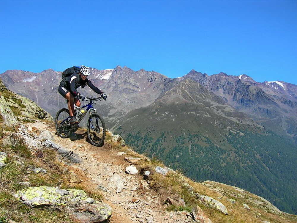
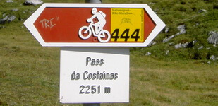
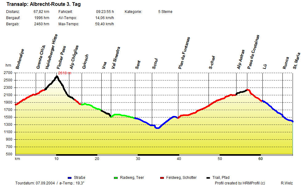
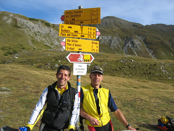
3. Tag: Königsetappe über den Fimberpass und Pass da Costainas
Strecke: 64,3 km, 2063 hm
Bodenalpe – Fimberpass – Vna – Sent – Scuol – S-charl – Pass da Costainas – Lü – Tschierv
- 2 %: Straße
- 20 %: Radweg, Teer, Nebenstraße mit wenig Verkehr
- 53 %: Feldweg, Schotter
- 25 %: Trail, Pfad
- GPS-Track: 03-ALR-Bodenalpe-Tschierv.gpx
siehe auch Variante nach St. Maria im Münstertal
- GPS-Track: 03-var-ALR-StMaria.gpx
Übersichtskarte
- schwarz: aktuelle Albrecht-Route
- rot: aktuelle Varianten der Albrecht-Route
- magenta: Ur-Route

Aktuelles Höhenprofil

Es ist in der Tat eine ordentliche Aufgabe, die heute vor uns liegt. Der Alpenhauptkamm wird zweimal bezwungen. Das sollte man nur bei gutem Wetter riskieren.
Noch ist es kühl, als wir uns an der Bodenalpe auf die Räder schwingen. Die Sonne taucht die Bergspitzen in ein rötliches Licht. Nach und nach ergreift sie Besitz vom Tal.

Die Schotterpiste ist gut fahrbar, mal mehr, mal weniger steil. An der Schweizer Grenze künden nur die Schilder davon, dass wir die Euro-Zone verlassen, zumindest offiziell.

Im Engadin ist die europäische Einheitswährung als zweites Zahlungsmittel neben dem Schweizer Franken akzeptiert. Wir unterbrechen die Fahrt immer wieder durch Fotopausen. Das Morgenlicht ist dazu ideal.

Nach einer guten Stunde ist die Heidelberger Hütte erreicht.

Alle Mountainbiker, die hier übernachtet haben, sind bereits ausgeflogen. Wir haben den Aufstieg zum Fimberpass für uns allein.

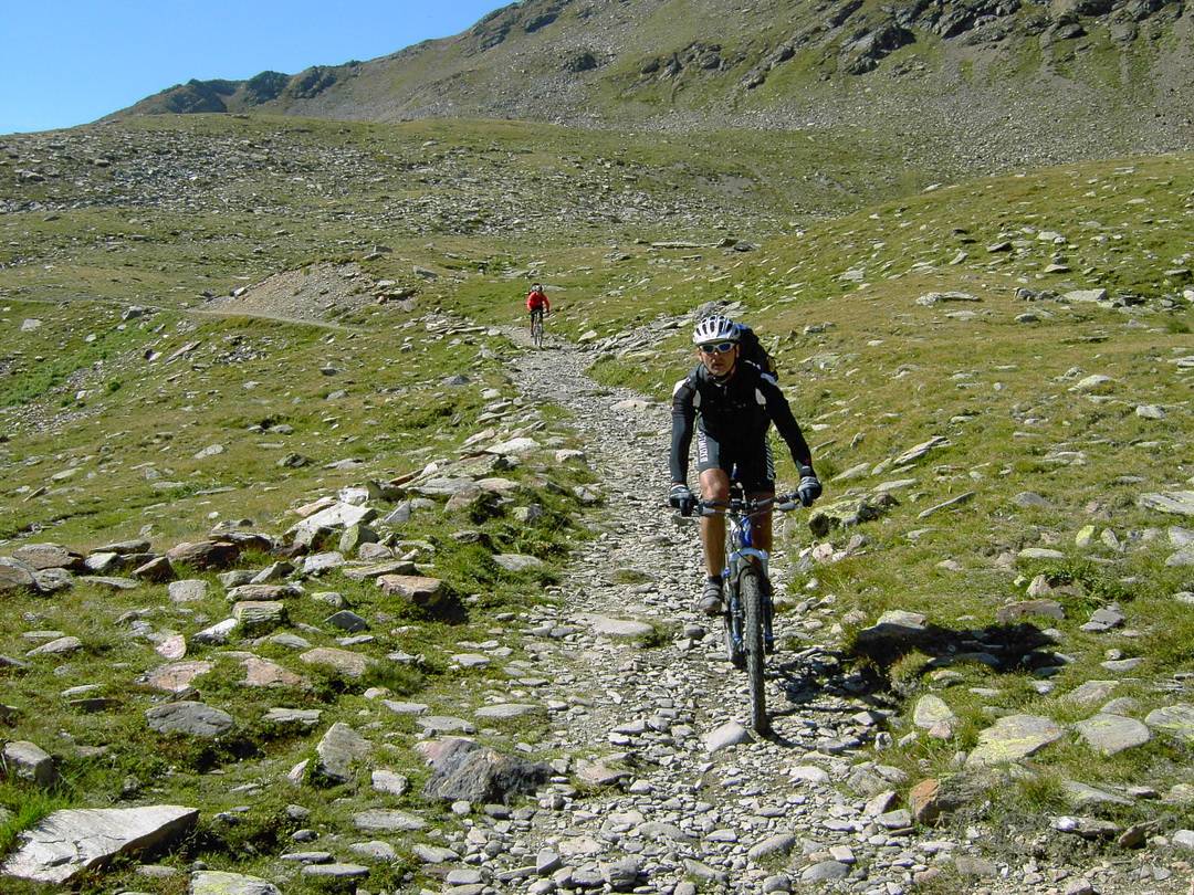
Der Weg zum Pass erfordert zwar ein paar Schiebepassagen, dauert aber kaum eine Stunde und ist sogar teilweise fahrbar.

In vielen Berichten steht folgendes geschrieben: Im Mittelalter sollen über diesen Pass die Toten aus Ischgl zum Friedhof nach Sent im Engadin gebracht worden sein, denn das Paznaun gehörte jahrhundertelang zur Gemeinde Sent. Im Winter war der Weg unbegehbar. Man ließ deshalb die Leichen einfrieren und brachte sie im Frühjahr in Sent unter die Erde. Klingt gut, oder nicht?
Weiterlesen…
Der Wahrheit kommt wohl folgende Version näher. Die Gemeinde Sent hatte sehr große Weidegebiete im Paznaun erworben. Ischgl gehörte lange Zeit kirchlich zu Sent. Es gibt eine alte Überlieferung über die Toten. Da sich die Senter nur im Sommer in Ischgl aufhielten, dürfte es nur sehr selten vorgekommen sein, dass Leichen für einen späteren Transport eingefroren wurden. (Quelle: Cla Rauch – Gemeinde Sent).
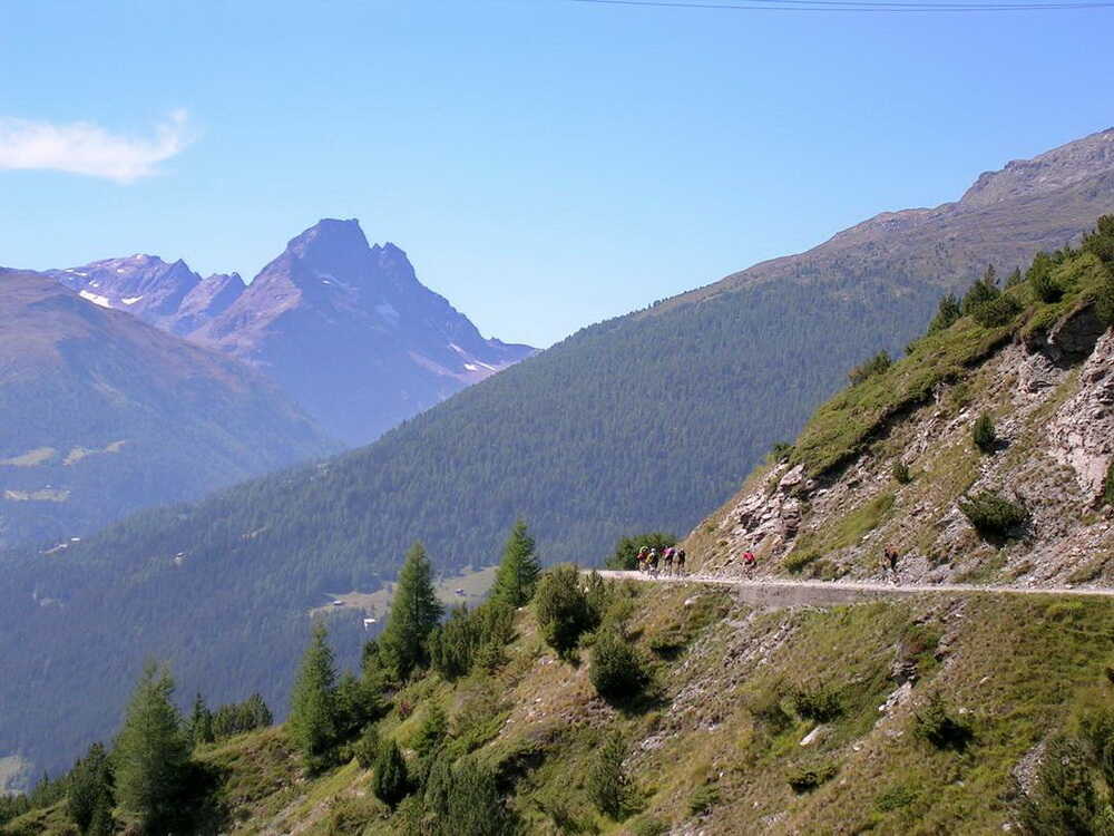
Wie dem auch sei. Am Fimberpass überschreiten wir eine Sprachgrenze. Im Unterengadin spricht man Rätoromanisch. Sie ist die vierte Amtssprache der Schweiz und hat ihre Wurzeln im Lateinischen. Wanderer und Biker grüßen sich mit „Allegra“. Der Pass heißt Cuolmen d’Fenga.

Nach und nach treffen alle am Pass ein und sind beeindruckt vom großartigen Panorama.

Die Abfahrt auf dem weithin einsehbaren Pfad gehört zu den berühmten Trails in den Alpen.

Wir genießen den anspruchsvollen Single-Trail ins Unterengadin.

Bis zur winzigen Alp Chöglias sind 500 Tiefenmeter zu überwinden. Je nach Fahrkönnen und Geländebeschaffenheit müssen einige Passagen geschoben werden. Heute hat der Trail den idealen Grip – nicht zu nass und nicht zu trocken. Sogar ich fahre weite Teile. Könner fahren bei guten äußeren Bedingungen fast die gesamte Strecke. Der Pfad ist teilweise ausgewaschen und führt an Abbruchkanten entlang. Bei entsprechender Vorsicht sollte das aber kein Problem darstellen.

Später überquert man eine abenteuerliche Bachbrücke und einen Gletscherbach.

Weiter geht es das Tal hinab.

Ab Griosch fahren wir weiter auf der guten Naturstraße in Richtung Vna. Kurz vor der Ortslage biegen wir scharf rechts ab in Richtung Val Sinestra. Später teilt sich der Wiesenweg. Der Wegweiser zeigt an, dass der untere linke Weg direkt zum Kurhaus führt. Er wird wenig später zum anspruchsvollen Wurzel-Trail, der an der Abbruchkante des Flusses steil nach unten geht. Nach einer Rechtskurve muss man Obacht geben. Hier ist ein Felsabbruch. Die dadurch entstandene Steilstufe ist ca. 1,50 Meter hoch.

Ich würde den Drop nicht riskieren.
Vom Kurhaus Val Sinestra führt eine schöne Naturstraße nach Sent. Der Ort liegt hoch über dem Inntal mit direktem Blick ins Val d’Uina. Von hier aus geht es über einen Panoramaweg hinab nach Scuol. Eine Rast am Supermarkt im Ortszentrum mit Auffüllung der Vorräte ist empfehlenswert.

Die Auffahrt nach S-charl ist eine reine Fleißaufgabe. Wenn die Säge klemmt: es gibt einen Bus, der im Rahmen der Kapazität Fahrräder mitnimmt.
Die Auffahrt führt im Val Minger durch eine Mondlandschaft.

Nach starken Regenfällen kann die Naturstraße durch Murenabgänge verschüttet sein. Der werden zwar immer so schnell als möglich beseitigt. Es kann aber kurzzeitige Sperrungen geben. Also auf der Tour immer die Augen und Ohren offenhalten.
Der Dorfbrunnen ist ein natürlicher Sammelpunkt.

Hier hält der Postbus. Wer Kräfte sparen will oder muss, kann seine Fahrräder in Scuol außen am Bus verstauen und sich kutschieren lassen. Ich hatte es HaPe vorgeschlagen, aber sein Ehrgeiz war stärker.
Weiterlesen…
Leider hat er seinem Knie damit keinen Gefallen getan. Bei der folgenden Auffahrt zur Alp Astras schwillt es stark an. Nichts geht mehr. Er muss zurück nach Scuol rollen. David überbringt uns an der Alp Astras diese Nachricht. Wir hatten schon besprochen, dass in solchen Fällen eine klare Entscheidung getroffen wird. Per SMS informiert mich HaPe, dass er in Scuol ein Hotelzimmer genommen hat und am nächsten Tag von seiner Nichte mit dem Auto abgeholt wird. Schade, dass er die Tour abbrechen muss, er war ein angenehmer Begleiter.
Falls man eine Pause in S-charl einlegen will: das „Crusch Alba“ liegt direkt am Weg.

Von S-charl aus führt der Weg entlang idyllischer Bergwiesen und einem munter murmelnden Bach.


Nur ein einziges steiles Stück kann einen aus der Puste bringen. Die Hochebene zur Alp Astras erweist sich immer wieder als Rennstrecke.

Christian und Matze sind die Sieger.

Von der Terrasse der Alp Astras haben wir einen weiten Blick zurück über die angenehm zu fahrende Strecke.

Der wunderschöne Trail zum Pass da Costainas ist gut fahrbar und ein Traum.

Einer aus der Gruppe opfert sich und öffnet und schließt ein Gatter. So können alle anderen Fahrer von sich sagen, den Pass komplett fahrenderweise bezwungen zu haben.
Ich bin immer wieder fasziniert von dieser einzigartigen Möglichkeit, den Alpenhauptkamm fahrenderweise zu bezwingen, ohne dass man auf einer Teerstraße fährt. Es ist wirklich ein Genuss für alle, die ewiges Schieben im unwegsamen Gelände satt haben. Andere sind ebenfalls fasziniert von den Möglichkeiten, sich am Pass zu entspannen.
Die Abfahrt enthält gleich zu Beginn ein kurzes, sehr steiles Schotterstück.

Leider macht Olaf dabei Bekanntschaft mit dem Untergrund. Eine ausgeprägte Schotterflechte ziert für den Rest der Tour seinen rechten Oberarm und den Unterschenkel.

Als wir die Wiese erreichen, sind die Schwierigkeiten vergessen. Eine Traumabfahrt auf gutem Schotter bis Lü wartet auf uns. Die Sicht ist fantastisch. Der Ortler mit seiner dicken Schneehaube liegt zum Greifen nah vor uns. Fotopause!

In Lü gibt es eine beliebte Rast- und Übernachtungsmöglichkeit, die Pension Hirschen. Wir fahren diesmal durch. Kurz nach dem Örtchen kreischt meine vordere Scheibenbremse erbärmlich. Der Bremsbelag ist komplett abgefahren. Zum Glück hat David passende Ersatzbeläge dabei. Ich war so dusselig, das vor der Tour nicht zu kontrollieren. Aus seinen eigenen Fehlern lernt man wohl am besten. Das wird mir nicht noch einmal passieren. Etappenende ist nach leichter Schotterabfahrt in Tschierv im oberen Münstertal.
Strecke: 67,7 km, 2065 hm
Bodenalpe – Fimberpass – Vna – Sent – Scuol – S-charl – Pass da Costainas – Lü – St. Maria im Münstertal
- 10 %: Straße
- 18 %: Radweg, Teer, Nebenstraße mit wenig Verkehr
- 47 %: Feldweg, Schotter
- 25 %: Trail, Pfad
- GPS-Track: 03-var-ALR-StMaria.gpx (von Lü bis St. Maria im Münstertal)
So sind wir bei der Ur-Route gefahren. Der Grund war die Übernachtung in der damaligen urigen Jugendherberge „Chasa Plaz“, die ich von vorherigen Touren kannte. Wegen des warmen Spätsommerwetters konnte unsere Pasta-Party im Freien stattfinden. Es wurde relativ früh dunkel. Wir saßen noch lange im Freien zusammen. Das Glühen der Berge zeigte an, dass morgen wieder ein herrlicher Tag auf uns warten würde.
Hinweis: die Jugendherberge gibt es inzwischen nicht mehr.

Aktuelles Höhenprofil der Variante nach St. Maria im Münstertal

- bei Schneegefahr auf dem Fimberpass im Inn-Tal bleiben und via Pfunds, Martina auf dem Inn-Radweg bis Scuol
- siehe zum Beispiel Albrecht-Route eMTB – 2. Tag oder Albrecht-Route Gravelbike

- Diese Entscheidung muss ggf. schon auf der 2. Etappe ab Landeck getroffen werden.
- Das ist mir auch schon einmal auf der Bodenalpe passiert. Ich musste umkehren und zurück über Landeck fahren. Danach ging es weiter durch das Inntal.
- Wir mussten damals sogar über den Reschenpass, um ins Münstertal zu gelangen
3. Tag: 68 km, 1996 hm
Bodenalpe – Fimberpass – Vna – Sent – Scuol – S-charl – Pass da Costainas – Lü – St. Maria im Münstertal
Lü
Pension Restaurant Hirschen Lü
- CH-7534 Lü/Val Müstair – hirschen-lue.ch
- Telefon: +41 81 858 51 81
- langjährige Übernachtungsmöglichkeit für Transalpler auf der Albrecht-Route (Mama Lü ist eine Legende!)
- Zimmer sind einfach und mit viel Holz in einem alten Bündner Haus eingerichtet
- 4 Zimmer mit neuer Etagendusche/WC, 1 Doppelzimmer mit Dusche/WC, 1 Zimmer im EG: insgesamt Platz für 18 Personen
- für Mountainbiker wird die Feinwäsche über Nacht gratis gewaschen und getrocknet
- W-LAN im ganzen Haus
- ordentliches BIkerfrühstück
- Abendessen: hausgemachte regionale Spezialitäten (z.B. Gerstensuppe, Capuns, Plain in Pigna oder eine Platte mit Bio-Produkten, Fleisch und Käse aus dem Val Müstair)
- ich bin selber dort seit Jahren immer wieder gerne

B&B Sasaalba
Rechtzeitig vor dem drohenden Regen finden wir auf unserer Verifizierungstour freundlichen Unterschlupf bei Anna Maria Bott in Lü. Dort betreibt sie liebevoll das B&B Chasa Sassalba. Wir sind ganz angetan und bleiben gleich über Nacht.
- B&B Sassalba: am Ortsanfang von Lü direkt an der Albrecht-Route gelegen
- Via Maistra 22, 7534 Lü
- Telefon: +41 79 667 32 02

Tschierv
Hotel Al Rom
- Hotel Al Rom: direkt an der Ofenpass-Straße gelegen
- Via Val Müstair 38, CH – 7532 Tschierv
- Tel.: +41 (0)81 858 55 51
Bei Ankunft kann das Fahrrad gereinigt und über Nacht in der abschließbaren Bikegarage abgestellt werden. Wäscheservice möglich gegen einen kleinen Obolus.

Sta. Maria im Münstertal
Chasa Jaro
Janine Hofer bietet fünf Doppelbettzimmer in einem sehr alten Haus an (ca. 800 Jahre), welches liebevoll restauriert ist. Alle Zimmer sind alte Holzstuben. Man teilt sich das moderne Badezimmer und das Gäste-WC mit anderen Bewohnern. Da es nur wenige Zimmer gibt, ist die Anzahl der Gäste überschaubar. (Tipp von Karsten Voß)
- Via Veglia 95 (bzw. Döss da Punt 95)
- CH-7536 Sta. Maria Val Müstair GR
- Telefon Janine Hofer: +41 76 570 14 93
- www.chasa-jaro.ch
Keine Gewähr für die Aktualität und Richtigkeit der Angaben. Hinweise zu Änderungen und Alternativen nehme ich gerne entgegen – siehe Kontakt
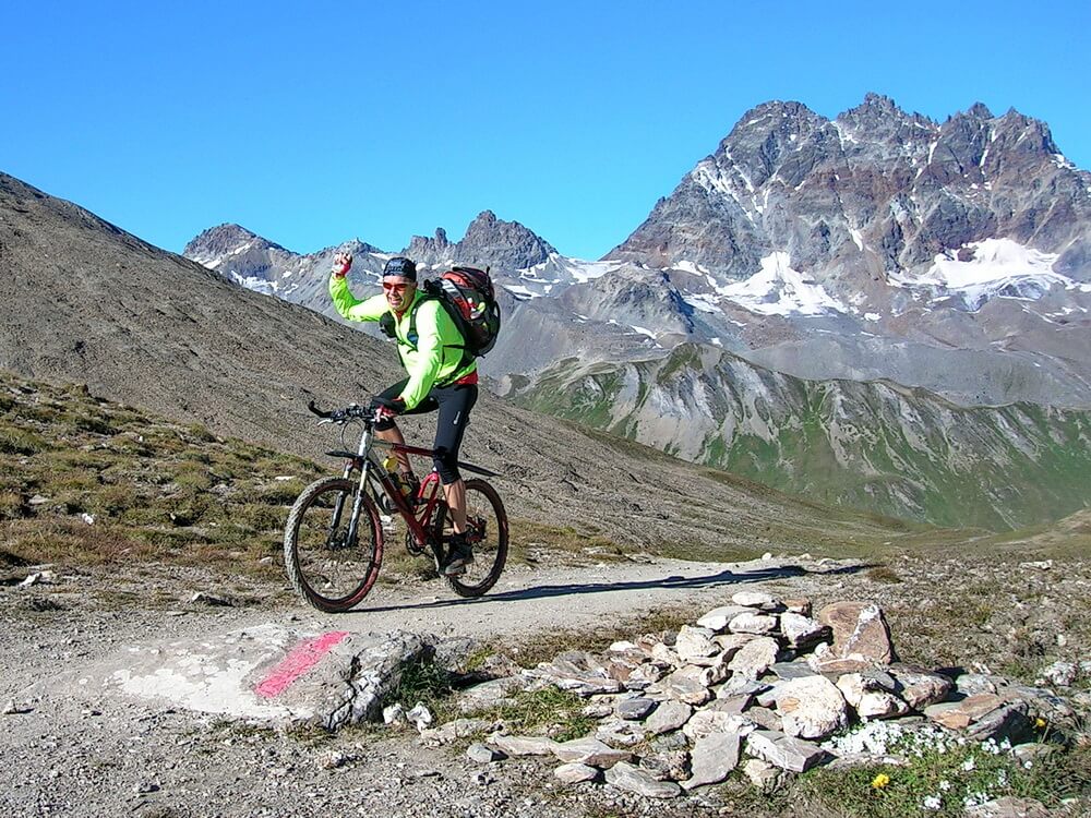
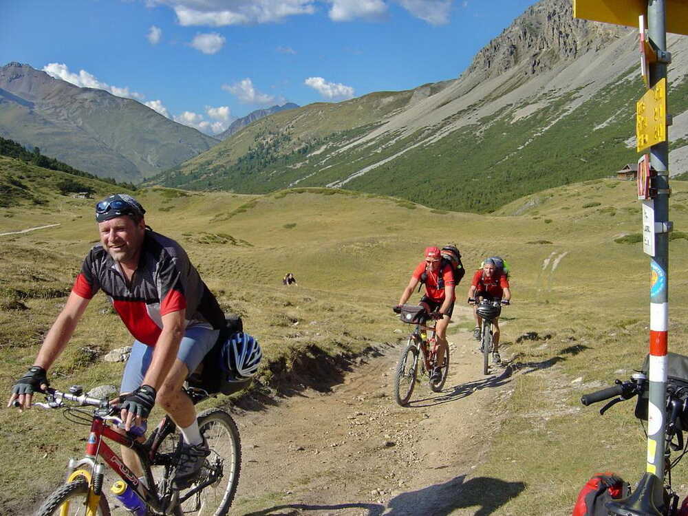
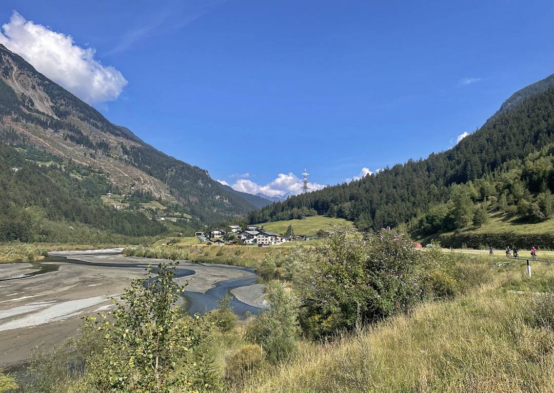
4. Tag: Val Mora, Passo di Verva

Strecke: 77,7 km, 1370 hm
Tschierv – Val Mora – Lago Cancano – Torri di Fraele – Arnoga – Passo di Verva – Eita – Grosio
- 10 %: Straße
- 17 %: Radweg, Teer, Nebenstraße mit wenig Verkehr
- 62 %: Feldweg, Schotter
- 11 %: Trail, Pfad
- GPS-Track: 04-ALR-Tschierv-Grosio.gpx
siehe auch Variante ab St. Maria im Münstertal und ab Torri di Fraele über Bormio
- GPS-Track: 04-var-ALR-StMaria-PraVau.gpx
- GPS-Track: 04-var-ALR-Torri-di-Fraele-Bormio.gpx
Übersichtskarte
- schwarz: aktuelle Albrecht-Route
- rot: aktuelle Varianten der Albrecht-Route
- magenta: Ur-Route

Aktuelles Höhenprofil

Nach dem Start in Tschierv folgt die Strecke dem MTB-Weg 444, der inzwischen Teil des Nationalpark-Marathons ist. Dieser wird von den Schweizern jedes Jahr im August ausgerichtet. Nach einer schönen Einrollstrecke über Fuldera verlieren wir etwas Höhe, ehe in Runca die Auffahrt zum Döss Radond beginnt. Bei Pra da Vau wird es etwas flacher und eine Wasserstelle gibt Gelegenheit, die Trinkflaschen nachzufüllen. An der Weggabel mündet die Nebenroute ein, die in St. Maria im Münstertal begonnen hat und bis hierher deutlich steiler und anstrengender ist.

Nächster Sammelpunkt und Wasserstelle ist in der Nähe der Alp Praveder.

Nach einer kurzen Rast sind die letzten Höhenmeter zum Döss Radond schnell vergessen.

Kurz hinter der Alpe ist es soweit.

Das Ziel des ersten Anstieges des Tages ist in Sichtweite.

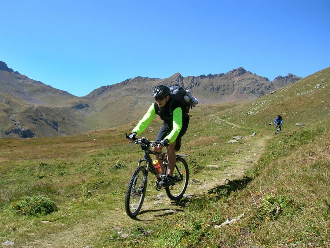
Wir finden alle wieder zusammen. Es ist sonnig, aber ein wenig frisch. Wir sind in den Bergen ganz allein unterwegs, abgesehen von den vielen Murmeltieren, die sich durch ihr charakteristisches Pfeifen bemerkbar machen. Matze kann die Geräusche täuschend echt nachmachen. Es ist, also ob sie sich unterhalten. Wir ziehen die Windjacken über und genießen die Abfahrt durchs Val Mora.

Hier verlief im Mittelalter eine alte Handelsstraße. Sie verlor ihre Bedeutung, als andere Passübergange entstanden sind wie der Pass Umbrail. Der Umbrail ist mit 2601 m zwar deutlich höher als der Döss Radond (2234 m). Der Weg ist im unteren Teil des Val Moras sehr erosionsgefährdet.
Das Hochtal ist bei diesem Wetter einfach überwältigend. Wir halten oft an und schauen auf die uns umgebenden Dreitausender.

Die Bilder brennen sich ein. Diese alpine Kulisse sucht ihresgleichen. Wildromantisch ist es hier. Man meint, jeden Moment könnte Winnetou um die nächste Wegbiegung geritten kommen. Es werden in der Tat immer mehr Wanderreiter im Val Mora gesichtet.

Die Schotterpiste wird zu einem Wiesentrail, der sich später durch Krüppelkiefern schlängelt.


Ab der Bachbrücke wird das Tal schmaler. Der Pfad zieht sich an der linken Flussseite durch die Geröllhalden und zwingt einen ab und an zum Absteigen. Wer nach einem schneereichen Winter zu früh im Jahr oder nach starken Regenfällen unterwegs ist, kann Pech haben. Dann kann es passieren, dass der Weg nach einem Lawinenabgang im Winter oder einem Murenabgang im Sommer verschüttet ist.

In der Regel kann man ab Mitte Juni den Trail passieren. Er wird von der Schweizer Seite aus betreut. Infos zum aktuellen Zustand erhält man bei der Touristinfo im Val Müstair.
Wir nähern uns der grünen Grenze am Passo Val Mora.

Am Passo Val Mora verlassen wir die Schweiz über die grüne Grenze.

Nach der grünen Grenze sind wir in Italien. Wer die Augen nicht aufsperrt, bekommt die Grenze gar nicht mit.

Am Passo di Fraele geraten die Stauseen ins Blickfeld. Der erste See ist der Lago di San Giacomo di Fraele.

Wir halten uns bei der Seeumfahrung rechts. Der zweite See ist der Lago di Cancano.

Wir passieren die Einmündung des Schotterweges vom Passo di Alpisella. Am Rifugio San Giacomo stehen die Liegestühle einladend in der Sonne. Kaffeepause!

Als ob sich seit unserem letzten Aufenthalt nichts verändert hätte, ist das kleine Kätzchen wieder zur Stelle und turnt auf David herum.

Wir fahren weiter, immer die Schotterpiste am See entlang. Oberhalb der Staumauer halten wir beim Rifugio Monte Scale an und bewundern die Bergwelt. Das Sommer-Skigebiet des Stilfser Jochs ist deutlich zu erkennen. Klar zeichnen sich die dunklen Liftmasten über dem weißen Schnee ab.

Der Zickzackweg durch die Felswand des Valle Forcola ist gut sichtbar. Bei solchem Wetter ist das eine wunderbare Strecke. Von Santa Maria aus wäre es jedenfalls möglich, diese Variante zu fahren.
Weiterlesen…
Man müsste in dem Fall das Val Mora auslassen und die wenig befahrene Straße zum Pass Umbrail nehmen. Dann ginge es weiter auf dem Höhentrail zur Bocchetta di Forcola. Eine schwere Entscheidung: bisher ist sie bei mir immer zu Gunsten des Val Mora ausgefallen. Irgendwie erscheint mir diese Route logischer. Die Variante über die alten Militäranlagen aus dem 1. Weltkrieg ist eher passend als Fortsetzung einer Transalproute, wenn man vom Stilfser Joch her kommt. Diese Idee ist inzwischen in der Albrecht-Route Top of the Rocks umgesetzt.
Weiter geht’s in Richtung Torri di Fraele.

An den Torri di Fraele sind wir nicht alleine.


Wer oben steht, hat gewonnen!
In unserer Gruppe geht es friedlicher zu. Wir begutachten die vor uns liegende Strecke.

Nun gut, über den folgenden Weg brauche ich nicht lange zu rätseln. Nach den Torri di Fraele geht es in der dritten Serpentine rechts ab Richtung Arnoga, über die Schotterpiste „Decauville“.


Entstanden ist die Strecke für eine Kleinbahn beim Bau der Stauseen Lago di San Giacomo e Fraele und Lago di Cancano.
Dafür brauchen wir heute viel Zeit, nicht weil wir müde sind, sondern weil uns der Anblick überwältigt und wir immer wieder innehalten, um alles in uns aufzunehmen.

In den letzten Tagen habe ich in Anbetracht der uns umgebenden landschaftlichen Highlights immer wieder gesagt: „Am nächsten Tag wird es noch einen Zacken schärfer!“ Es stimmt tatsächlich. Das ist das Schöne an dieser Traum-Transalp. Die Eindrücke eines Tages werden von den Impressionen des nächsten übertroffen.
In Arnoga machen wir Halt, um einen Cappuccino zu trinken. Die Rast war unnötig, wie ich im Nachhinein feststellen musste. Durch die Pause verliert man die Lockerheit in den Beinmuskeln, die sich auf der langen Flachstrecke eingestellt hat. Die kann man am Passo di Verva gut gebrauchen. Matze und Christian fahren die schwere Schotterpiste komplett durch. Alle anderen schieben ab und zu.

Schließlich erreichen wir die Passhöhe.
Den Schotter-Downhill nach Eita lassen wir ruhig angehen.

Immer wieder unterbrechen wir die Abfahrt. Es wäre eine Sünde, diese beeindruckende Landschaft einfach an sich vorbeiziehen zu lassen.

Der Felsen in der Nähe des Rifugio Falcks gibt Gelegenheit zum Herumkraxeln und Herumschauen. Wenig später kommt das kleine Bergdörfchen Eita ins Blickfeld.


Im Bergdörfchen Eita hat uns das Leben wieder. Hier wird noch ursprüngliche Landwirtschaft betrieben, allem Anschein nach meist von den älteren Bewohnern des Tales.
Weiterlesen…
Ein Bauer und seine Frau sind damit beschäftigt, mit Hilfe einer Art Häckselmaschine den Dung zu zerkleinern, um ihn besser auf die Felder aufbringen zu können. Im Vorgarten eines kleinen, uralten Bauernhauses liegt ein alter Mann im Schatten. Er hat sich in Filzdecken eingemummelt, seine Frau ruht neben ihm. Ich grüße freundlich: „Buon giorno!“. Sie nicken und wünschen uns eine gute Reise: „Buon viaggio, ragazzi!“ Es wirkt wie eine Idylle. Ich kann mir gut vorstellen, wie hart das Leben hier oben war. Es ist sicherlich nicht einfach für ursprüngliche Lebensformen, sich in der heutigen Zeit zu behaupten. Aber wir sollten uns bemühen, ihre Lebensräume zu schützen und zu bewahren, damit auch zukünftige Generationen die Schönheit und Vielfalt dieser Natur erleben können. Ich denke vor mich hin: „Die Leute hier oben würden wahrscheinlich besser zurechtkommen, wenn sie sich selbst behelfen müssten. Ganz im Gegensatz zu uns verstädterten Menschen des 21. Jahrhunderts mit all unserem Schickimicki-Kram wie Handy, vollgefedertem Bike und GPS.“
Nun ist es aber genug mit dem Philosophieren. Es geht abwärts ins Valtellina. Das Etappenziel Grosio ruft.

In Grosio wartet das „Hotel Sassella“ auf uns. Die rasante Abfahrt über 1000 Höhenmeter auf der kleinen Straße bläst alle fragenden Gedanken aus dem Kopf. Die mediterrane Luft des Valtellina tut ein übriges, um keine bohrenden Zweifel über Sinn oder Unsinn einer Transalp aufkommen zu lassen. Freudig begrüße ich Marcella und Jim Pini, den Chef des familiär geführten Hotels. Ich fühle mich wie zu Hause.

Strecke: 72,7 km, 1576 hm
St. Maria im Münstertal – Pra da Vau – Val Mora – Lago Cancano – Torri di Fraele – Arnoga – Passo di Verva – Eita – Grosio
- 12 %: Straße
- 15 %: Radweg, Teer, Nebenstraße mit wenig Verkehr
- 62 %: Feldweg, Schotter
- 11 %: Trail, Pfad
- GPS-Track: 04-var-ALR-StMaria-PraVau.gpx (von St. Maria i.M. bis Pra da Vau)
dann weiter wie Hauptroute mit GPS-Track: 04-ALR-Tschierv-Grosio.gpx
Bei unserer Tour auf der Ur-Route starteten wir in St. Maria. Buchstäblich aus dem Stand geht es nur bergauf. Und das bis Pra da Vau auf einer sehr steilen Schotterpiste. Dort ist nun die Verbindung mit der Hauptroute, wie oben beschrieben.
Aktuelles Höhenprofil der Variante Start in St. Maria im Münstertal über Passo di Verva nach Grosio

Strecke: 72,0 km, 871 hm
Tschierv – Val Mora – Lago Cancano – Torri di Fraele – Premadio – Bormio – Tola – Le Prese – Sondalo – Grosio
- 6 %: Straße
- 41 %: Radweg, Teer, Nebenstraße mit wenig Verkehr
- 41 %: Feldweg, Schotter
- 12 %: Trail, Pfad
- GPS-Track: 04-var-ALR-Torri-di-Fraele-Bormio.gpx
Von den Torri di Fraele geht es auf den Serpentinen und parallelen Trails hinab nach Premadio und weiter auf Rad- und Nebenwegen hinunter bis Grosio. Dabei passiert man im Valdisotto bei Aquilone die Stelle des katastrophalen Val Pola-Bergsturzes vom 28. Juli 1987 (siehe das Bild in der folgenden Fotostrecke).
Wenn man die Albrecht-Route als 6-Tages-Tour fahren will, empfiehlt sich diese Variante. Ab Le Prese fährt man gleich zur „La Baita“ ins Val Rezzalo (verkürzt die Transalp um einen Tag): siehe den Bericht zu einer 6-Tage-Tour.
Aktuelles Höhenprofil der Variante ab Torri di Fraele über Bormio und den Sentiero Valtellina nach Grosio

Bilder an der Strecke der Variante ab Torri di Fraele über Bormio und den Sentiero Valtellina nach Grosio
Wenn man von den Torri di Fraele auf der Nebenstraße nach Premadio abfährt, gibt es einen schönen High Speed Trail.

Ab Premadio über Bormio bis Grosio verläuft die Strecke fast durchgängig auf schönen Radwegen entlang der Adda bis Grosio. Die fehlenden Teilstücke werden weiter ausgebaut.
Der Radweg verläuft inzwischen fast durchgängig abseits der Straße von Bormio bis an den Comer See. Zwischen Aquilone und Le Prese kann man im Tal der Adda noch immer die Spuren des gewaltigen Bergrutsches von 1987 sehen. Das führte dazu, dass der Gaviapass asphaltiert wurde, da die Straße nach Bormio verschüttet war.
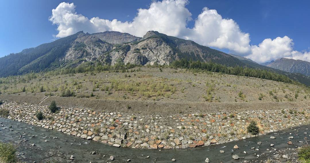
Detaillierte Informationen zum Bergsturz vom 28. Juli 1987: hier.
Wenn man am 5. Tag die Hauptroute über Val di Rezzalo fahren will, kann man sich überlegen, ob man von Grosio aus noch bis nach Sondalo fährt und dort im HOTEL DELLE ALPI übernachtet. Das liegt im Ortsteil Bolladore direkt an der Albrecht-Route. Von Grosio bis Bolladore sind es ca. 5 km und 150 Höhenmeter.
4. Tag: 72,5 km, 1503 hm
St. Maria im Münstertal – Val Mora – Lago Cancano – Arnoga – Passo Verva – Eita – Grosio
Grosio
- Hotel Sassella, I-23033 Grosio, Via Roma 2 +39-0342-847272, super Küche, Sauna; www.hotelsassella.it

Inzwischen ist aus dem Albergo ein Hotel geworden, das im Sommer gut von Transalplern frequentiert wir. Davon sind die meisten auf der Albrecht-Route unterwegs.
Grosotto
- Hotel Le Corti, I-23034 Grosotto, Via Patrioti 73, Tel.: +39-0342-848624 www.garnilecorti.it
Sondalo-Bolladore
- HOTEL DELLE ALPI 23035 Sondalo (SO), Via Bolladore, 19, Tel.: +39-0342-801412 (liegt an der Nebenroute)
Übernachtungstipps an der Variante über Bormio
Bormio
- Hotel Giardino, Via Per Piatta, 11, 23032 Bormio SO, Italien, Tel.: +39 0342 903132
- HOTEL Funivia, Via Funivia, 34, 23032 Bormio SO, Italien, Tel.: +39 0342 903242
- Ostello Alpino, Via Milano, 88, 23032 Bormio SO, Italien, Tel.: +39 0342 902712
Keine Gewähr für die Aktualität und Richtigkeit der Angaben. Hinweise zu Änderungen und Alternativen nehme ich gerne entgegen – siehe Kontakt
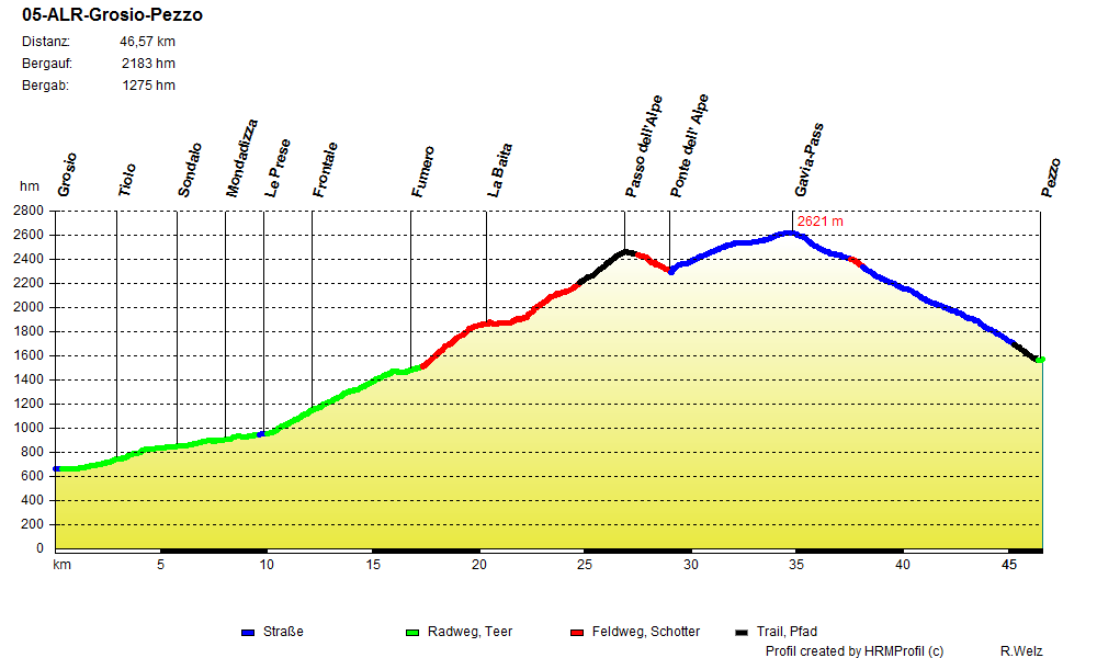
5. Tag: Val di Rezzalo, Gaviapass
Strecke: 46,6 km, 2183 hm
Grosio – Le Prese – Fumero – Val di Rezzalo – Passo dell‘ Alpe – Gaviapass – Pezzo
- 35 %: Straße
- 36 %: Radweg, Teer, Nebenstraße mit wenig Verkehr
- 20 %: Feldweg, Schotter
- 9 %: Trail, Pfad
- GPS-Track: 05-ALR-Grosio-Pezzo.gpx
siehe auch Variante über Passo Foppa/Mortirolo, Col Carette
- GPS-Track: 05-var-ALR-Mortirolo.gpx
- GPS-Track: 05-var-ALR-PdLegno-Pezzo
Übersichtskarte
- schwarz: aktuelle Albrecht-Route
- rot: aktuelle Varianten der Albrecht-Route
- magenta: Ur-Route

Aktuelles Höhenprofil
Ein prüfender Blick am Morgen zum Himmel. Wolkenschleier hängen am Himmel. Talabwärts ist eine dunkle Wolkenformation zu sehen, die anscheinend langsam näher kommt. Sollte uns das Wetterglück verlassen?
Weiterlesen…
Ich berate mich mit David, der sich ebenfalls mit den Wetteranzeichen in den Alpen auskennt. Wir analysieren die Lage: kein starker Wind, kein starkes Absinken der Temperaturen über Nacht. Der Luftdruck ist in etwa gleich geblieben. Nichts deutet auf einen gravierenden Umschwung der Wetterlage hin. Bei schlechten äußeren Bedingungen würde ich auf keinen Fall über das Val di Rezzalo zum Gaviapass fahren. Als wir ca. zwei Kilometer nach Grosio den Abzweig zum Passo Foppa/Mortirolo erreichen, schieben sich die ersten Berggipfel durch die Wolken. Sie entpuppen sich als Hochnebel. Keine Frage, wir fahren zum Val di Rezzalo. Per email hatte ich vorsorglich unsere Durchreise bei Alessandro, dem Hüttenwirt von La Baita angekündigt. Unterwegs überholt uns Alessandro im Auto. Offensichtlich ist er auf dem Weg zur Berghütte. Wir werden erwartet.
Die steile Auffahrt nach Fumero beginnt in Le Prese. Die Straße ist gut befahrbar und hat kaum Verkehr.

Die Sonne hat die letzten Nebelschwaden vertrieben und heizt uns tüchtig ein. Wasserstellen gibt es unterwegs genug. Am Ortsende von Fumero ist ein Parkplatz. Wir warten, bis die letzten eintrudeln.

Uli hat es langsam angehen lassen und erreicht als letzter den Treffpunkt. Er ist offensichtlich gut eingefahren. Mit einem erfrischenden, „Auf geht’s, Jungs!“, rollt er ohne Pause weiter. Seine Leistungsfähigkeit setzt uns immer wieder in Erstaunen. Nach dem letzten Wanderparkplatz beginnen die Steilstücke.

Teilweise ist die Strecke mit groben Steinplatten gepflastert. Die Zwischenräume sind durch Kies und Sand zugespült. Es ist trotzdem ein zähes Fahren. Ich suche, soweit es geht, den schmalen Streifen am Rand, der mit dem Mountainbike besser zu befahren ist. Eine dreiviertel Stunde quält man sich ein bisschen. Dann öffnet sich das Hochtal bei San Bernardo.

La Baita erreicht man über einen Abzweig, der mit einem kurzen steilen Anstieg gewürzt ist.

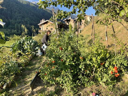
Es ist immer wieder eine Offenbarung, dass es so etwas Schönes gibt. In einer Höhe von 1800 bis 1900 Metern liegen einzelne Gehöfte verstreut im Tal. Strommasten sucht man vergeblich. Vereinzelt wird ein wenig Landwirtschaft betrieben. Viele der alten Hütten sind in der letzten Zeit behutsam instand gesetzt worden und dienen als Wochenendhäuschen oder Sommerfrische für die Leute aus dem Tal.
Die Terrasse von „La Baita“ liegt in der Sonne. Wir schlürfen Latte Macchiato und genießen den selbstgemachten Heidelbeerkuchen.

Ich freue mich, Alessandro wiederzusehen. Wir tauschen in einem Gemisch aus Deutsch und Italienisch Erinnerungen aus. Er betreibt die einzige Übernachtungsmöglichkeit für durchreisende Transalpler im Tal. Inzwischen genießt La Baita einen legendären Ruf in der Transalp-Szene.
Weiterlesen…
Strom gewinnt die Hütte durch einen kleinen Generator, der durch Wasserkraft betrieben wird. Seit einigen Jahren kommen immer mehr Urlauber ins Tal, angeregt durch die verschiedenen Tourberichte im Internet. Wer hier übernachten will, sollte unbedingt vorher reservieren (www.rezzalovacanze.com) oder einen Tag vorher anrufen, da die Hütte nicht immer besetzt ist. Bei der Tourplanung ist es für mich immer eine schwere Entscheidung, soll ich nun in Grosio oder in „La Baita“ übernachten. Beide Orte haben ihre speziellen Reize. Leider liegen sie so dicht nebeneinander, dass man sich für eine von beiden Möglichkeiten entscheiden muss. Bei meinen Touren habe ich mich immer wieder einmal für „La Baita“ entscheiden – eine gute Wahl. Als wir bei Alessandro bezahlen wollen, winkt er nur ab: „Mille gracie per pubblicita!“, sagt er zu mir. Ich bedanke und verabschiede mich für dieses Mal.

Frisch gestärkt machen wir uns an die Weiterfahrt.

Die Trasse wurde einst aus militärischen Gründen gebaut. Bis zu den letzten Gehöften auf einer Höhe von ca. 2200 m ist sie als breite Schotterpiste ausgebaut. Die erste Hochebene wird über eine steile Serpentinenstrecke erreicht.

Auf dem ersten Plateau liegt Saleit.

Weiter geht es steil bergauf.

Die Sonne knallt auf uns nieder. Uli hatte angekündigt, dass er eine kleine Badepause im eiskalten Bergbach einlegen will. Diesmal hat er sogar extra ein Thermometer mit, 6° Celsius zeigt es an. Er war schon ein verrückter Hund.

Je nach Kondition und Gewicht des Rucksacks müssen trotz des hergerichteten Weges einige Schiebepassagen eingelegt werden. Wie nicht anders zu erwarten, bleiben Matze und Christian bis weit über das zweite Plateau hinaus im Sattel. Nach der zweiten Brücke ist für die meisten Schluss. Inzwischen wurde der Weg bis zur Passhöhe instand gesetzt. Der Weg ist trotzdem sehr steil. Da geht bei den meisten nichts mehr, außer gemütlich das Rad zu schieben und ab und zu anzulupfen.

Das allerletzte Stück zum Passo dell’Alpe ist wieder fahrbar.
Die Sonne scheint, es weht ein kühler Wind. Keiner hält sich deshalb lange am Pass auf. Nach der Passhöhe rasten wir ausgiebig in einer windgeschützten Mulde an einem Gletscherbach.

Kein Mensch außer uns ist zu sehen. Es herrscht Stille um uns, nur ab und zu unterbrochen durch das Pfeifen der Murmeltiere. Langsam entschließen wir uns aufzubrechen. Solche schönen Tage weit oben in den Bergen sind selten und man sollte sie genießen. Schließlich machen wir uns auf den Weg hinab zur Gaviapass-Straße.

An der Ponte dell’Alpe beginnt die relativ leichte Auffahrt auf Asphalt zum Gaviapass.

Am Rifugio Berni hat man einen guten Blick auf den Dosegu-Gletscher zwischen Punta San Matteo und Pizzo Tresero.

Interessant ist der Vergleich mit dem Jahr 2015, als ich das folgende Bild machte.

Der Rückgang des Gletschers innerhalb von 11 Jahren ist recht deutlich zu sehen. Ob das nun auf die viel beschworene Klimaerwärmung von Menschenhand zurückzuführen ist oder nur die Folge normaler Temperaturschwankungen im Laufe der Erdgeschichte, wer weiß das schon so genau? Das Ziel dieser Transalp, der Gardasee, lag in der letzten Eiszeit unter einer mehrere hundert Meter dicken Eisdecke begraben. Heute sind die Ufer mediterran geprägt. Da stelle ich mir die Frage, was damals die Ursache für die Erwärmung und das Ende der Eiszeiten war. Einflüsse durch den Mensch können es nicht gewesen sein.
Egal, wir sind in der Jetztzeit unterwegs. Es sind noch ein paar Höhenmeter bis zum Gaviapass. Jeder tritt sein Tempo. Kurz vor dem Ziel wird die Straße am Lago Bianco relativ flach.

Das ist immer ein Signal für ein kleines Wettrennen, wenn zwei Mountainbiker nicht weit auseinander liegen. Ich trete an, Olaf liegt in meinem Windschatten und will vorbeiziehen. Ich denke, lass ihn den Punkt für die Bergwertung holen und will ihn abklatschen. Er versteht es offensichtlich als Zeichen, gemeinsam einzurollen. Das tun wir.

Wir räkeln uns vor dem Berggasthaus in der knallenden Sonne und genießen die Aussicht. Hier sind wir umgeben von stolzen Bezwingern der Passhöhe: Rennradlern, Cabriofans und den unvermeidlichen Motorradfahrern!
Die Abfahrt vom Pass beginnt mit der rasanten Fahrt durch eine Mondlandschaft. Riesige Steinblöcke liegen links und rechts der Straße. In einer Kehre halten wir an. Tief unter uns liegt das Pendant zum Lago Bianco – der Lago Nero.

Wir bleiben ein Stück auf der Gaviapass-Straße. Am Tunnel, den wir rechts umfahren, genießen wir kurz das Feeling des alten Schotterpasses. Die Straße wurde erst Ende der 1980er Jahre komplett asphaltiert.


Jetzt ist die Straße komplett asphaltiert. Der Grund ist folgender: ein gewaltiger Erdrutsch blockierte 1987 die Straße von Sondalo nach Bormio (siehe die Infos dazu im Bericht zur Nebenroute des 4. Tages). Der Gaviapass war die einzige Zufahrtsmöglichkeit von Süden her. Die Straße wurde damals in kurzer Zeit geteert. David kennt sie noch im ursprünglichen Zustand.
Am Felsen studieren wir die Inschrift einer Gedenktafel. Im Jahre 1954 sind hier 54 Alpini ums Leben gekommen. Der Fahrer eines Militärlasters verlor die Kontrolle über sein Fahrzeug und riss die jungen Soldaten in den Tod. Frische Blumen zeugen davon, dass ihrer noch gedacht wird. Nachdenklich schauen wir in die einige hundert Meter tiefe Schlucht, ehe wir weiterfahren.

Auf dieser Seite des Gaviapasses ist die Straße stellenweise so schmal, dass nur ein Auto passieren kann. Bei der Abfahrt bieten sich tolle Ausblicke auf die Adamello-Presanella-Gruppe! Die Landschaft ist einfach atemberaubend.

Im unteren Teil wird die Straße breiter und wir heizen mit High-Speed ins Tal. In einer scharfen Rechtskurve auf einer Höhe von ca. 1700 m verläuft ein feiner Singletrail nach Pezzo.

In Pezzo endet diese Etappe. Das kleine italienische Bergdorf liegt strategisch günstig für die Albrecht-Route, wenn man am nächsten Tag die Montozzo-Scharte in Angriff nehmen will.

Dort gibt es das „Da Giusy“ mit 3 Zimmern, in denen bis zu 14 Biker unterkommen können. Im Restaurant kann man am Abend essen gehen.
Morgen ist der Montozzo angesagt. Wird der Wettergott uns weiter gewogen sein?
Strecke: 40,7 km, 1751 hm
Grosio – Passo Foppa/Mortirolo – Col Carette – Vezza d’Oglio – Ponte di Legno – Pezzo
- 43 %: Straße
- 48 %: Radweg, Teer, Nebenstraße mit wenig Verkehr
- 8 %: Feldweg, Schotter
- 0 %: Trail, Pfad
- GPS-Track: 05-var-ALR-Mortirolo.gpx
- Vor allem sinnvoll bei Schlechtwetter und Gewittergefahr in den Bergen.
- Dann ist die Fahrt über Val di Rezzalo und Gaviapass zu gefährlich.
- Ab Grosio auf kaum befahrener Nebenstraße zum Passo Foppa/Mortirolo.
- Weiter auf landschaftlich überragender Strecke via Col Carette nach Vezza d’Oglio.
- Im Valcamonica schöner Radweg nach Ponte di Legno.
- Die Variante über den Passo Foppa/Passo Mortirolo wird dadurch deutlich aufgewertet.
- Sinnvoll, wenn man am 6. Tag nicht über die Montozzo-Scharte fahren kann oder will, sondern auf die Nebenroute über den Passo Tonale ausweicht.
Aktuelles Höhenprofil der Variante über Passo Foppa/Mortirolo und Col Carette ins Valcamonica

Wenn man bis Pezzo weiterfahren möchte, dann verlängert sich die Strecke wie folgt:
GPS-Track: 05-var-ALR-PdLegno-Pezzo.gpx
Aktuelles Höhenprofil der Variante über Passo Foppa/Mortirolo Valcamonica bis Pezzo


Der unterschiedliche Sprachgebrauch Mortirolo/Foppa ist verwirrend. Die Geschichte ist schnell erzählt.
Weiterlesen…
De facto gibt es sowohl den einen als auch den anderen. Der Passo del Mortirolo liegt abseits der Straße, wenn es nach dem Passo della Foppa hinunter nach Monno geht. Der eigentliche Straßenpass ist der Foppa. Der Hotelchef Jim Pini vom legendären „Hotel Sassella“ in Grosio hat mir die Zusammenhänge erklärt. Foppa ist wie gesagt die alte, richtige Bezeichnung für den Straßenpass. Als dann der Giro d’Italia einige Male über diesen Pass führte, benutzte ein Reporter aus Unkenntnis den Namen des Passes del Mortirolo, der Luftlinie keinen Kilometer entfernt liegt, aber nur auf einem Wanderweg zu erreichen ist. Ich habe es überprüft.

Das Schild ist da! Nur zu Fuß zu erreichen oder mit dem Mountainbike auf dem Weg 435, ca. 500 m und 90 Höhenmeter oberhalb des Albergos Mortirolo.
Was der eine Reporter sagte, haben dann alle nachgeplappert und so bürgerte sich im Laufe der Zeit der „falsche“ Name für den „richtigen“ Pass ein. Durch die offenkundig hochwirksame normative Kraft des Faktischen ist inzwischen auch der Name „Foppa“ von den Wegweisern vor Ort verschwunden. Allerdings gibt es auch eine Geschichte zum Namen des Passes von den Leuten aus dem Valcamonica. Das liegt von Grosio aus auf der anderen Seite. Sie sagten schon immer, dass sie zum Mortirolo gehen. Also akzeptieren wir das als guten Kompromiss und verwenden je nach Lust und Laune beide Bezeichnungen.
Wie dem auch sei, im Jahre 2006 habe ich bei meiner Rennrad Transalp an einem Holzpfahl noch diesen verblichenen Schriftzug vorgefunden.

Historisches Foto: Passo Foppa – so stand es dereinst auf dem Schild geschrieben! Was währt schon ewig?
Inzwischen hat der Passo del Mortirolo aufgerüstet. Es gibt einen Container mit Möglichkeit zum Waschen, Umziehen und Aufwärmen.

Ohne eine Selfie Point geht heutzutage gar nichts mehr.

Davor befindet sich ein stabiler Pflock, auf dem man ein Smartphone in der richtigen Höhe abstellen kann, damit das Selfie gelingt. Eine Rastmöglichkeit gibt es im Albergo Mortirolo, das etwas unterhalb der Passhöhe liegt.

Zur Nebenroute über den Col Carette nach Vezza d’Oglio muss man ein paar dutzend Meter zurück zum Abzweig der Almstraße fahren. Die Strecke ist einfach, aber landschaftlich sehr reizvoll.
Bei gutem Wetter empfiehlt sich am Col Carette ein kurzer Abstecher über einen alten Militärweg zum Pianaccio.

Dort hat man eine fantastische Rundsicht zum Passo Tonale, der Adamello-Pressanella-Gruppe und hinunter ins Valcamonica.
Die Abfahrt vom Col Carette erfolgt zunächst auf einer geteerten Almstraße.
Später folgen Abschnitte auf Schotter und Waschbeton, die einige steile Bergabpassagen enthalten. Den Talgrund erreicht man in Vezza d’Oglio. Dort kann man rasten.

Rechts an der Waldkante verläuft der Radweg im Valcamonica, der Einschnitt im Hintergrund links ist der Passo Tonale.
Mit oder ohne Pause geht es auf dem Radweg weiter nach Ponte di Legno zum Hotel Raggio di Luce. Das dient als Ziel für die Fahrer der Nebenroute, insbesondere für diejenigen, die am nächsten Tag auf der Nebenroute bleiben und direkt zum Passo Tonale fahren.

Carla, die Hotelchefin, spricht so rasend schnell Deutsch wie ihre Muttersprache Italienisch. Ich bin jedes Mal aufs Neue fasziniert. Das blitzsaubere Hotel liegt in ruhiger Lage etwas oberhalb von Ponte di Legno. Wer hier Station macht, hat bei dieser kurzen Etappe ausreichend Zeit für einen Stadtbummel.

5. Tag: 50 km, 2254 hm
Grosio – Le Prese – Fumero – Val di Rezzalo – Passo dell‘ Alpe – Gavia-Pass – Ponte di Legno
Val di Rezzalo
- Rifugio La Baita, Mobil: +39-3407953688, www.rezzalovacanze.com, Alessandro spricht deutsch
Pezzo
- Da Giusy – 3 Zimmer für 14 Biker

Ponte di Legno
- Hotel Raggio di Luce, Chefin Carla spricht perfekt deutsch, sichere Bikegarage mit Waschmöglichkeit, Wäscheservice auf Anfrage
25050 Temu, Via Valeriana 46 – loc. Plazza (Vorort von Ponte di Legno)
Tel. +39 0364 900852 – mobil. +39 338 1140510
Auf Anfrage bereitet Carla gerne ein Abendessen mit Produkten aus der Region und aus ihrem Bio-Garten direkt am Haus zu (siehe folgende Bilder).
Keine Gewähr für die Aktualität und Richtigkeit der Angaben. Hinweise zu Änderungen und Alternativen nehme ich gerne entgegen – siehe Kontakt
6. Tag: Montozzo
Strecke: 60,3 km, 2169 hm
Pezzo – Case di Viso – Montozzo-Scharte – Lago di Pian Palu – Pejo – Fucine – Val di Sole – Dimaro – Madonna di Campiglio
- 11 %: Straße
- 41 %: Radweg, Teer, Nebenstraße mit wenig Verkehr
- 35 %: Feldweg, Schotter
- 11 %: Trail, Pfad
- GPS-Track: 06-ALR-Pezzo-Madonna.gpx
siehe auch Variante über Passo Tonale
- GPS-Track: 06-var-ALR-Passo-Tonale.gpx
- GPS-Track: 06-var-ALR-Tonalina.gpx
Übersichtskarte
- schwarz: aktuelle Albrecht-Route
- rot: aktuelle Varianten der Albrecht-Route
- magenta: Ur-Route
Aktuelles Höhenprofil

Am Morgen ist es diesig in den Berge. Es ist eindeutig Hochnebel. Keine zwei Sekunden brauche ich zu überlegen, um zu wissen, dass heute die Montozzo-Scharte ruft. Pezzo erwacht langsam, da sitzen wir schon auf den Rädern.

Nach dem Start erreichen wir schnell Case di Viso. Hier endet die Straße und die Schotterpiste beginnt. Die langgezogenen Serpentinen zeichnen sich deutlich am Berghang ab.

Im Hintergrund rechts sieht man die Auffahrt in Richtung Bozzi-Hütte. Die Montozzo-Scharte ist der Einschnitt ganz rechts im obigen Bild.
In Case de Viso erinnert ein kleines Denkmal an den 1. Weltkrieg, in dessen Folge die Militärstraße zur Montozzo-Scharte entstand. Heute bietet das Tal ein friedliches Bild. Hoffen wir, dass es immer so bleibt.

Zunächst moderat ansteigend und gut fahrbar kommen bald ein paar steilere Stellen, die manch einen kurz aus dem Sattel zwingen. Die Sonne verbirgt sich hinter den Nebelschleiern. Das ist uns recht. Bei der ersten Erkundung und bei der Tour Top of the Rocks hatten wir pralle Sonne beim Anstieg. Das war nicht das reine Vergnügen.


Bis zum Rifugio Bozzi al Montozzo zieht sich das Feld weit auseinander. Matze zieht durch, wahrscheinlich wieder auf dem großen Kettenblatt.

Das Rifugio Bozzi liegt auf einem kleinen Sattel mit traumhafter Aussicht auf die Berge und ins Tal. Die Nebel verziehen sich just in dem Moment, als wir alle wieder beisammen sind.

Wir machen eine ausgedehnte Pause und besichtigen die Überreste der alten Stellungen und Kriegsbauten.


Was hier oben verteidigt werden sollte, will sich mir zum wiederholten Mal nicht erschließen. Die Verteidigungslinien zogen sich hinüber bis zum Passo Tonale. Der alte Weg über den Passo dei Contrabbandieri ist noch vorhanden und wäre eine Erkundung wert.
Meine Gedanken gehen ein paar Jahre zurück. Im September 2000 stand ich schon mal dort oben. Just in dem Moment, als wir die Scharte erreichten, brach ein Gewitter mit Hagelschauern los. Der Regen verwandelte die Schotterpiste in einen Sturzbach. Total verdreckt und durchnässt suchten wir in Pejo Zuflucht in einem Hotel. Ähnliche Wetterkapriolen sollten sich wiederholen, als wir mit Roland Schymik zu Dreharbeiten für die DVD „Abenteuer Alpencross 2 – Die Albrecht-Route“ unterwegs waren. Wir übernachteten damals im Rifugio Bozzi und fanden am Morgen eine leichte Schneedecke vor – und das im Juli. Schaut euch das Bild an. Wintersachen sollte man also immer dabei haben, selbst im Hochsommer.

Bei dieser Tour ist der Wettergott auf unserer Seite. Die Sonne hat alle Nebelfetzen in der Höhe längst verjagt.

40 Prozent Steigung, aber gleich ist es geschafft.


Montozzo Scharte: der zweithöchste Übergang nach dem Gaviapass, der höchste Off-Road Übergang bei der Albrecht-Route.

An der Montozzo-Scharte haben sich Überreste von Schützengräben erhalten. Eine kleine Gedenktafel erinnert an die sinnlosen Opfer dieses Gebirgskrieges. Wir halten inne und lassen das grandiose Panorama der Cevedale-Gruppe auf uns wirken. Weit über 3500 Meter sind die Berge hier hoch. Die Sicht ist unglaublich klar, der Himmel stahlblau. Der Trail ist vom höchsten Punkt beginnend zunächst gut fahrbar.
Impressionen des Montozzo-Trails
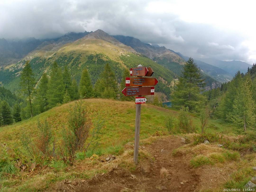
Ein paar Mal queren wir kleine Bäche, die im Spätsommer nicht viel Wasser führen. Nach einer kleinen Almhütte wird der Weg steiler. Von einem Felsplateau öffnet sich plötzlich der Blick auf den türkisblauen Lago di Pian Palu, der rund 500 Höhenmeter tiefer im Talkessel liegt.

Der Weg 111 gabelt sich bei ca. 2150 Metern. Links oder rechts? Egal, beide führen zum Stausee und haben ihre speziellen Reize. Zwischenzeitlich war mal der linke Abzweig als Trail für Mountainbiker vorgesehen, wie das folgende Bild zeigt.

Wir haben damals den rechten Abzweig genommen. Mittlerweile ist das Teil einer offiziellen lokalen MTB-Route.
Auch der Singletrail hinunter zum Lago di PIan Palu ist teilweise recht anspruchsvoll. Sicherlich ein Leckerbissen für alle Fahrtechniker mit ein paar Appetithäppchen wie diesem.

Wir überqueren ein paar Bäche. Dieser ist besonders spannend.

Matze fährt vorneweg und wartet an einer sonnigen Stelle, damit alle aufschließen können. Es dauert eine Weile. Dann kommt Reiner. Er hat einen kleinen Überschlag hinter sich. Der Helm hat Schlimmeres verhütet . Wir begutachten die Delle im Material. Ohne Kopfschutz hätte das Böse ausgehen können. Olaf und David fehlen noch. Matze und ich laufen schließlich ein Stück zurück. Doch kein Grund zur Sorge. Olaf hat eine Bachquerung genutzt und seine Schürfwunde am Bein ausgewaschen. Als wir die Staumauer erreichen, liegen alle kniffligen Stellen hinter uns.

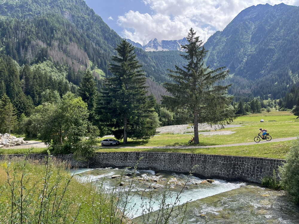
Ein Angler zieht gerade eine große Forelle aus dem Wasser, „Buon appetito!“, rufe ich ihm zu. Wir schauen eine Weile seinen Bemühungen zu, den Fisch aus dem Wasser zu bringen. Schließlich fahren wir los. Bis zur Fontanino di Pejo geht es eine gute Schotterstraße abwärts. An der Quelle füllen die Einheimischen das Wasser in große Kanister ab. Dem heiligen Nass werden heilende Kräfte zugeschrieben. Die Straße wird langsam zur Asphaltpiste. In Pejo halten wir kurz an. In den Serpentinen hinab ins Tal zweigt nach rechts ein Radweg ab, der rasch an Höhe verliert. Er führt direkt zum Radweg im Val di Sole. Auf diesem ziehen wir durch bis Dimaro.

Olaf und ich geben uns abwechselnd Windschatten, so dass wir in Windeseile in Dimaro sind. Es ist früher Nachmittag, der Supermarkt hat noch geschlossen. Zeit für eine Rast. Die Sonne brennt heiß. Wir essen im Schatten ein paar Kleinigkeiten, denn es liegen reichlich 800 Höhenmeter im Anstieg vor uns.
Wenn es Probleme mit den Bikes geben sollte, liegt direkt am Weg das B&B Jolly.

Roberto gab mir den Tipp für die neue Routenführung in Dimaro. Ein kleiner Schlenker über Carciato umgeht die Passage auf der oft stark befahrenen Straße in Richtung Madonna di Campiglio. Man kommt dann direkt im Val Meledrio raus.

Der MTB-Weg nach Madonna di Campiglio verläuft im Val Meledrio und ist gut ausgeschildert. Entlang der Flanke der Brenta bieten sich herrliche Ausblicke auf die Felsentürme der Gebirgsgruppe. Es ist schön, wenn man zwischen dem Treten, Schwitzen und Luftholen Zeit und Lust findet, um den Blick schweifen zu lassen.

Man schreibt es englischen Bergfreunden zu, dass sich von der Brenta aus der alpinistische Tourismus entwickeln konnte. Durch eine Vielzahl von Klettersteigen gehört der Bergstock zu einem der am besten erschlossenen alpinen Wandergebiete. Mittlerweile hat sich der MTB-Tourismus etabliert. Die Wegmarkierungen sind eindeutig: immer den Schildern Richtung MTB-Madonna folgen. Der Weg führt am Rand eines Canyons entlang.

Den Canyon überqueren wir auf einer überdachten Holzbrücke.

Dann wird der Weg flacher und bleibt im Schatten der Bäume bei sehr angenehmen Temperaturen.

Es folgen ein paar steilere Abschnitte, ehe man sich bei der Malga Pra del Mazza in die Nähe der Autostraße befindet. Auf die Straße zu wechseln ist keine Versuchung. An der Malga Mondifra füllen wir zum letzten Mal Wasser in die Trinkflaschen.

Am Waldrand verläuft die Schotterpiste der Auffahrt – gleich ist es geschafft! Bei einem kleinen Lift ist der höchste Punkt erreicht und es geht abwärts.

Am Golfplatz ist es vollbracht. Es geht nur noch abwärts!
Das Hotel „Arnica“ meines Freundes Matteo liegt mitten im Zentrum von Madonna di Campiglio. Matteo war damals gerade mit den Planungen für seine erste Transalp beschäftigt. Da komme ich gerade recht. Ich empfehle ihm unsere gerade eben gefahrene Strecke. Einer seiner Begleiter kommt dazu und ich zeige ihnen anhand meiner gescannten Karten die Route. Der Einfachheit halber überlasse ich ihnen gleich die Blätter und wünsche ihnen viel Glück und gutes Wetter für ihre Tour. Das hat geholfen. Nach gelungener Transalp schickte mir Matteo (rechts im Bild) ein Foto vom Pass da Costainas.
Wir lassen den Tag in einer Pizzeria ausklingen, nehmen einen Absacker an der Bar unseres Hotels und verkrümeln uns zeitig ins Bett.
Strecke: 57 km, 1892 hm
Ponte di Legno – Passo Tonale – Baita Velon – Fucine – Val di Sole – Dimaro – Madonna di Campiglio
- 7 %: Straße
- 49 %: Radweg, Teer, Nebenstraße mit wenig Verkehr
- 42 %: Feldweg, Schotter
- 2 %: Trail, Pfad
- GPS-Track: 06-var-ALR-Passo-Tonale.gpx
Die Nebenroute startet in Ponte di Legno am Hotel Raggio di Luce und verläuft danach auf dem Radweg Val Sozzine. Dabei passiert man direkt die Seilbahn zum Passo Tonale (geöffnet Anfang Juni bis Anfang September, nimmt Fahrräder mit). Der Radweg verläuft seit 2025 komplett abseits der Staatsstraße SS 42 bis zum Parkplatz der Seilbahn Paradiso. Das ist ca. 1 km vor dem Passo Tonale. Bis dorthin kann auf dem Seitenstreifen der Straße fahren. Damit hat sich die Variante über den Passo Tonale entscheidend verbessert.
Aktuelles Höhenprofil der Variante über Passo Tonale

Wenn man sich in Pezzo entscheidet, die Montozzo-Scharte auszulassen, erreicht man über den Verbindungsweg Tonalina die Staatsstraße SS 42. Kurz nach dem Hotel La Roccia kann man auf den Radweg zum Tonalepass wechseln.
GPS-Track: 06-var-ALR-Tonalina.gpx
Aktuelles Höhenprofil der Variante über Passo Tonale ab Pezzo

In Ponte di Legno beginnt die Auffahrt zum Passo Tonale. Ab dem Val Sozzine zunächst ein Stück parallel zur Staatstraße SS 42. Dann folgen ein paar steile Rampen bis zur Mittelstation der Seilbahn Ponte di Legno – Passo Tonale.

In der Nähe der Mittelstation der Seilbahn geht es weiter auf dem geteerten Radweg in Richtung Passo Tonale. Insgesamt viel besser als die früher notwendige Fahrt auf der oftmals stark befahrenen Staatstraße zum Passo Tonale.
Diese Nebenroute gibt es aus gutem Grund. Schnee ist im Hochgebirge im Sommer möglich, wie das folgende Bild zeigt. Es ist Zeit für eine Pause. Gegenüber vom Kriegerdenkmal ist eine Kaffeestube zum Aufwärmen.


Im Talgrund bei Stavel geht es dann vor der Brücke rechts auf Schotterpiste kurz bergauf. Dann links abwärts bis Volpaia.
6. Tag: 64 km, 2217 hm
Ponte di Legno (Precasaglio) – Pezzo – Montozzo-Scharte – Pejo – Fucine – Dimaro – Madonna di Campiglio
Dimaro
- Hotel „Serena“, tel.: +39-0463-974974 – I-38025 Dimaro, Via Gole 90, sehr gute Zimmer, hervorragendes Essen: www.serena-hotel.com
- B&B Jolly: +39-0463-974206, Via Gole 154, www.jollydimaro.it
Madonna di Campiglio
- Hotel Arnica
- 38086 Madonna di Campiglio, Via Cima Tosa 32
- tel +39-0465-442227

Die Albrecht-Route ist inzwischen in Madonna di Campiglio im Sommergeschäft ein schöner Nebenerwerb, nicht nur für das Hotel Arnica.
- Hotel Vidi
- Madonna di Campiglio, Via Cima Tosa, 50
- TEL: 0039-0465-443344
- Bed and Breakfast, mit Sauna und Restaurant, zentral gelegen, Supermarkt in der Nähe
- Sonderpreis für Biker, Garage, Möglichkeit für Reparaturen und Bikewäsche, Wäscheservice für Bikeklamotten
- Garni dello Sportivo
- Madonna di Campiglio, Via Pradalago, 29
- Tel.: 0039-0465-441101
- Im Zentrum von Madonna di Campiglio, an der Seilbahn Pradalago. Sehr gutes Frühstückbuffet. Sichere Bike-Garage. Wäsche-Service.
- Famiglia Stefani
Keine Gewähr für die Aktualität und Richtigkeit der Angaben. Hinweise zu Änderungen und Alternativen nehme ich gerne entgegen – siehe Kontakt
7. Tag: Gardasee

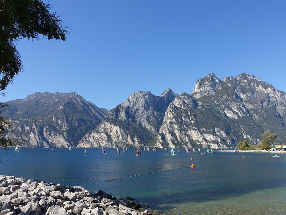
Strecke: 67,7 km, 1155 hm
Madonna di Campiglio – Val d’Agola – Passo Bregn de l’Ors – Passo del Gotro – Albergo Brenta – Val d’Algone – Stenico – Ponte Arche – Cure – Passo Ballino – Tennosee – Villa del Monte – Tenno – Deva – Riva – Torbole
- 26 %: Straße
- 37 %: Radweg, Teer, Nebenstraße mit wenig Verkehr
- 31 %: Feldweg, Schotter
- 6 %: Trail, Pfad
- GPS-Track: 07-ALR-Madonna-Torbole.gpx
siehe auch Variante entlang der Sarca
- GPS-Track: 07-var-ALR-Stenico-Sarca.gpx
Übersichtskarte
- schwarz: aktuelle Albrecht-Route
- rot: aktuelle Varianten der Albrecht-Route
- magenta: Ur-Route

Aktuelles Höhenprofil

Es ist frisch, als ich am Morgen aus dem Fenster blicke. Die Sonne steigt langsam über die Berge. Es wird wieder ein schöner Tag. Passend zum Abschluss dieser grandiosen Tour. Das Frühstück ist reichhaltig: Käse, Wurst, Marmelade, Obst und eine Vielzahl verschiedener Kuchen. Wir schaffen uns damit eine gute Grundlage, denn mit größeren Essenspausen unterwegs wollen wir uns nicht aufhalten.

Wir fahren durch das Ortszentrum, am See vorbei durch den kühlen Wald in Richtung Rifugio Vallesinella. Auf einem Trail geht es abwärts zum Wasserfall. Das Rifugio Cascata di mezza ist noch geschlossen.

Wir überqueren die kleine Holzbrücke.

Danach fahren und schieben wir gemütlich den folgenden Single-Trail entlang.

Am Anfang ist der Wurzeltrail feucht und glitschig durch den ständigen Sprühnebel des Wasserfalls. Bald erreichen wir eine Forststraße, die uns abwärts in Richtung Malga Brenta bringt.

Aus den Wiesen steigt der Tau auf. Die morgendliche Stimmung ist märchenhaft. Die Schotterpiste das Val d’Agola hinauf ist nur mäßig steil und lässt sich hervorragend fahren. Ich teste mich mal aus und bleibe an Matze und Christian dran bzw. sie reduzieren ihr Tempo so, dass ich folgen kann. Bald ist der Hohlweg erreicht, der zum Lago d’Agola führt.

Am See wird traditionsgemäß Rast in der Nähe des abgestorbenen Baumstumpfes gemacht.

Wir sitzen noch im Schatten, da erhebt sich die Sonne über die Bergspitzen der Brenta. Nach und nach erstrahlt der still da liegende See im gleißenden Sonnenlicht. Gemächlich nehmen wir die kurze, heftige Schiebepassage in Angriff. Ich feure Christian an, der die Wiese so weit hochfährt, bis es nicht mehr geht. Eine starke Leistung!

Der letzte größere Anstieg vor dem Gardasee wird bezwungen. Später verläuft der Pfad im Wald.

Der Bärenpass ist erreicht.

Am Bärenpass verschnaufen wir für ein Gruppenfoto. Noch weiß keiner von uns, dass wir ein Stück Transalpgeschichte geschrieben haben.

Danach lassen wir die Glocke der Kapelle erklingen und bereiten uns auf die Abfahrt vor.

Erst muss noch der Passo del Gotro bezwungen werden, das geht schnell. Im Spätsommerdunst liegt das Val d’Algone vor uns.

Eine traumhafte Abfahrt wartet auf uns.

Es folgen rund 700 Höhenmeter abwärts auf Schotter bis zum Rifugio Brenta. Danach sind es weitere 500 Tiefenmeter auf einer kleinen Asphaltstraße.

Am Talende verstauen wir die Windjacken. Es ist deutlich wärmer geworden. Erstaunlicherweise bläst uns diesmal in Richtung Stenico der Wind nur mäßig ins Gesicht. Jeder sucht trotzdem so gut es geht einen Vordermann, der ihm Windschatten spendet. Auf der Piazza Centrale in Stenico werden die Punkte für die Sprintwertung vergeben.
Von hier aus gibt es mehrere Möglichkeiten, den Gardasee zu erreichen.
Weiterlesen…
Die zwei klassischen Hauptvarianten kennen alle aus der Gruppe schon. Da ist zum einen der Weg über den Passo di Ballino eine oft gefahrene Möglichkeit. Landschaftlich sehr reizvoll ist zum anderen der Weg durch das einsame Val di Lomasone. Der Wermutstropfen ist allerdings, dass man dabei sehr steile Schiebestücke auf alten Römerpfaden zu überwinden hat (siehe meinen Tourbericht im Archiv). Beide Varianten belohnen den erfolgreichen Transalpler mit dem ersten Blick auf den Gardasee aus mehreren hundert Metern Höhe. Während unserer Ostertourenwoche am Gardasee sind wir beide Alternativen gefahren und entscheiden uns für die leichtere Variante entlang der Sarca. Sie wird weiter unten als Nebenroute beschrieben.
Unangefochten ist inzwischen die Strecke über Ponte Arche und auf Nebenwegen zum Passo Ballino fester Bestandteil der Hauptroute. Sie wird hier und im Transalp Roadbook 1 dokumentiert und beschrieben.
In Stenico geht es den Berg hinab. Schnell ist Ponte Arche erreicht. Auf schönen Schotterwegen geht es weiter zum Passo Ballino.

Schließlich ist der Passo del Ballino erreicht. Es geht nur noch bergab.

Man kann den Gardasee schon förmlich riechen. Vorher passieren wir den Tennosee.

Dann ist es soweit. Der Gardasee kommt zum ersten Mal ins Blickfeld.
Es ist immer wieder ein tolles Gefühl. Nur wenig später passieren wir den Ort, der dem Tennosee seinen Namen gab.

Es geht abwärts auf alten Karrenwegen durch die Weinberge. Schließlich erreicht man den Hafen von Riva.

Die Jungs gaben später den Anstoß für die Albrecht-Route Top of the Rocks.
Zum Abschluss erfolgt die beeindruckende Fahrt am Ufer des Gardasees entlang, hinüber nach Torbole.


Hier trifft die Nebenroute durch das Sarcatal wieder auf die Hauptroute. Der Gardasee breitet sich in seiner ganzen Pracht vor uns aus.
Weiter geht es am Seeufer entlang.

Hoffentlich reicht die Konzentration für die letzten Meter? Bei der Ankunft am Gardasee möchte Matze am liebsten das Fahrrad gegen sein geliebtes Surfbrett austauschen, als er die Surfer auf dem Wasser sieht.

Noch ein paar Meter den Strand entlang und wir stehen vor dem Strandcafé in Torbole, wo ich meine Transalps am Gardasee immer beende.
Finisher Ur-Route v.l.n.r.: Olaf , Matze (knieend), David, Andreas Albrecht, Reiner, Christian, Uli †
Der Gardasee ist die unangefochtene Nummer 1 als Ziel einer Transalp. Warum wohl? Die Bilder sprechen für sich.

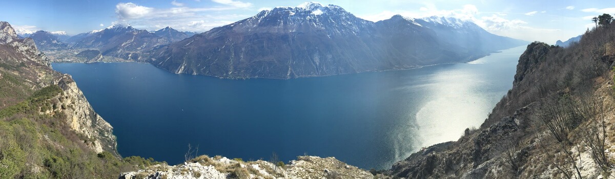
Der Gardasee ist von Nord nach Süd ca. 55 km lang. Es gibt unendlich viele Tourenmöglichkeiten, die ich in einigen Gardasee GPS Bikeguides beschrieben habe.
Strecke: 73,2 km, 919 hm
Madonna di Campiglio – Val d’Agola – Passo Bregn de l’Ors – Passo del Gotro – Albergo Brenta – Val d’Algone – Stenico – Premione – Ponte Sarca – Sarche – Pietramurata – Dro – Arco – Torbole
- 20 %: Straße
- 52 %: Radweg, Teer, Nebenstraße mit wenig Verkehr
- 23 %: Feldweg, Schotter
- 5 %: Trail, Pfad
- GPS-Track: 07-var-ALR-Stenico-Sarca.gpx
Aktuelles Höhenprofil der Variante entlang der Sarca

Bei der Ur-Route sind wir aus den oben beschriebenen Gründen diese Variante gefahren. Sie erfordert ab Stenico kaum zusätzliche Höhenmeter. Landschaftlich sehr reizvoll ist die Route auf der alten Sarca-Straße. In Jahrmillionen hat sich der Fluss zwischen Ponte Arche und Sarche in den Fels gegraben, bevor er bei Torbole in den Gardasee mündet. Wir überqueren die Schlucht auf der Ponte Sarca, die sich in einem kühnen Bogen über die Schlucht spannt.

Ein kurzes Stück müssen wir auf der Straße fahren. Der Seitenstreifen gibt uns genug Platz, um unbedrängt vom Verkehr schnell vorwärts zukommen. Ein Radweg trennt uns bald vom Verkehr. Vor dem ersten Tunnel zweigt er links ab. Er verläuft auf der Strada Vecchia im Sarcatal. Es ist ganz still hier. Der Fluss führt um die Jahreszeit wenig Wasser. Der alte Straßenbelag war damals übersät mit Gesteinsbrocken. Langsam holte sich die Natur die Straße zurück. Bäume und Büsche wuchsen durch den bröckelnden Asphalt. An manchen Stellen blieb nur eine schmale Gasse für uns übrig. In einer Kurve rollten wir vorsichtig an die kleine Mauer heran, die die Straße begrenzt. Senkrecht fällt die Felswand ab, unten gurgelt der Fluss. Da stockt einem der Atem. Drei Tunnel, durch die der Verkehr braust, umfahren wir elegant. Dieses Stück erinnerte mich an die alte Ponale-Straße. Sie könnte in etwa zur selben Zeit gebaut worden sein.
Inzwischen ist aus dieser alten Schluchtstrecke ein Radweg entstanden.

Schließlich endet diese Reise in die Vergangenheit oberhalb von Sarche.

Hier beginnt die fruchtbare Ebene, die sich vom Gardasee über Arco und Dro bis zum Lago Toblino erstreckt.Am Ortseingang von Sarche überqueren wir erneut die Sarca und biegen sofort auf den Radweg ab, der dem Flusslauf folgt. Entspannt rollen wir die letzten Kilometer zum Finale unserer Transalp. In Pietramurata führt der Radweg durch die Steinwüste der Marocche. Sie entstand durch den gewaltigen Abbruch einer ganzen Felswand des Monte Brento vor ca. 6000 Jahren.

Die Marocche ist ein charakteristisches Bergsturzgebiet, das durch Felsabbrüche vor einigen tausend Jahren entstanden ist. Dabei wurde eine gewaltige Steinwüste aus Felsblöcken gebildet.
Jetzt gibt es kein Halten mehr, n Höchstgeschwindigkeit rasen wir auf Dro zu. Wie Olaf immer sagt: „Ein Eis geht immer noch.“ Am Kreisverkehr in Dro befindet sich die Gelateria „Maui“. Hier gibt es weit und breit das beste hausgemachte Eis der Region, behaupte ich. Unsere Eisspezialisten Olaf und Reiner sind erst skeptisch, bestätigen aber meine Meinung.

Von Dro aus folgen wir dem Flusslauf der Sarca auf einem alten Karrenweg, der durch Olivenhaine führt.

Die kurze Pause in Dro gibt Schwung für den nun wirklich letzten Anstieg durch die Olivenhaine bei Ceniga. An der alten Römerbrücke bei Ceniga wird noch einmal Halt gemacht.

Es geth weiter, vorbei an den Kletterfelsen von Arco. In der Felswand ist immer viel los.

In Arco beginnt der letzte Teil der Nebenroute, entlang der Sarca an den Gardasee.


An der Brücke stößt die Nebenroute wieder auf die Hauptroute.
7. Tag: 75 km, 862 hm
Madonna di Campiglio – Val d’Agola – Passo Bregn de l’Ors – Val d’Algone – Stenico – Villa Banale – Sarche – Arco – Torbole
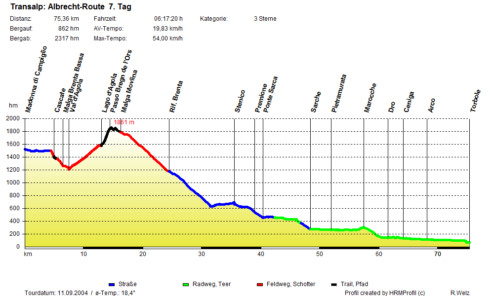
Torbole
- Villa Stella: Via Strada Granda, 104 – 38069 Torbole Tel + 39 0464 505354, www.villastella.it

- Aktivhotel Santalucia Via Santa Lucia 6, (Gps Via Pontalti), I-38069 TORBOLE SUL GARDA (TN), Tel.: 0039-0464-505140, www.aktivhotel.it
Keine Gewähr für die Aktualität und Richtigkeit der Angaben. Hinweise zu Änderungen und Alternativen nehme ich gerne entgegen – siehe Kontakt
Nach dieser Transalp war uns allen bewusst, dass wir etwas Besonderes erlebt hatten. Abgesehen vom Wetterglück sind wir eine traumhafte Route durch die Alpen gefahren. Meine jahrelange Recherche hatte sich ausgezahlt: Startort, Strecke, Zielort und Einteilung der Etappen. Alles fühlte sich rund an. Ich machte mich daran, die gefahrene Strecke zu dokumentieren. Das war eine Fleißaufgabe, ging aber mit der entsprechenden Routine zügig vonstatten. Es fehlte nur noch ein griffiger Name für die Transalp-Route.
Wie es zum Namen Albrecht-Route kam
Die Geschichte ist schnell erzählt.
2003 war ich mit einer Gruppe auf einer Transalp unterwegs, die in der Streckenführung der hier dokumentierten Route schon sehr nahe kam. Bei der Schiebepassage von der Heidelberger Hütte zum Fimberpass waren wir nicht alleine unterwegs und man kam mit anderen Transalplern ins Gespräch. Ein Mitglied meiner Gruppe wurde gefragt, was er denn für eine Strecke fährt und mit wem er unterwegs sei. Er antwortete, dass unsere Gruppe von Garmisch an den Gardasee fährt und dass Andreas Albrecht die Gruppe führt. Die Reaktion war die Gegenfrage: „Mit dem Albrecht?“
Ich wusste damals nichts von meiner zaghaft im Wachsen begriffenen Popularität und nahm das mit einem Achselzucken und ohne weiteren Kommentar meinerseits zur Kenntnis. Nach der Transalp schickte mir der betreffende Uwe Richter (übrigens ein Belgier) diese kleine Fotomontage.

Und so kam eins zum anderen. Ein Jahr später bin ich diese Ur-Route gefahren und suchte nach einem griffigen Namen. Ich dachte mir in einem kleinen Anflug von „Größenwahn“, warum nicht diese Transalp „Albrecht-Route“ nennen? Gesagt, getan! Jetzt muss ich mit den Folgen leben. 😉
Wie auch immer, am Ende des Tages bleibt die Frage:


Die Albrecht-Route lebt! An den Stellen, wo zu viel Asphalt als Untergrund vorkam, habe ich recherchiert und nach meinem Gefühl bessere Abschnitte gefunden, die dem grundsätzlichen Charakter der Strecke entsprechen, bzw. stärker unterstreichen. Dies ist ein fortlaufender Prozess, weil die Wege in den Alpen einer ständigen Veränderung unterworfen sind. Einige Verbesserungen habe ich direkt in die Hauptroute einfließen lassen (z.B. am 2. Tag die Passage zwischen Flirsch und St. Anton, die nun vollständig abseits der Hauptstraße verläuft). Andere Strecken sind in der Albrecht-Route v2 dokumentiert.
Hier stelle ich Videos vor, die geeeignet sind, sich einen Eindruck von der Strecke zu verschaffen. Wer sein Video hier veröffentlichen möchte, kann sich gerne mit mir in Verbindung setzen: siehe Kontakt.
Einen guten Eindruck vom Streckenverlauf bekommt ihr auf diesem You-Tube-Video. Danke an die KaAn Bikers!
Einen Überblick über die Strecke gewinnt ihr auch hier:
Rückreise, Shuttle, Gepäcktransport

Wenn man die Alpen mit dem Fahrrad überquert hat, kann man auch die Rückfahrt per Rad und mit öffentlichen Verkehrsmitteln organisieren. Das klappt mit Regionalzügen ohne Voranmeldung. Man muss nur etwas Geduld und Zeit mitbringen. Aber warum nicht, wenn man die Rückreise als Teil des Urlaubs auffasst? Entschleunigung ist das Motto – das passt doch perfekt auf diese Form des Reisens.
Konkret sieht die Rückfahrt so aus:
Strecke mit dem Fahrrad in zwei Abschnitten:
- ca. 60 km, ca. 300 hm
Mit dem Rad von Torbole nach Rovereto
- Torbole – Nago – Mori – Rovereto Bhf
- ca. 20 km, ca. 300 hm
- Radweg ist sehr gut ausgeschildert und nicht zu verfehlen
- GPS-Track: Radweg-Torbole-Rovereto.gpx
- Download: hier klicken
Übersichtskarte Radweg Torbole – Rovereto

Mit dem Zug von Rovereto zum Brenner
- mit Regionalzug bis Brenner (keine Reservierung notwendig)
- rechtzeitiges Erscheinen am Bahnhof sinnvoll
- ggf. Umsteigen in Bozen
Mit Rad vom Brenner nach Innsbruck
- Brenner – Gries am Brenner – Steinach a. B. – Matrei – Innsbruck
- ca. 39 km, ca. 10 hm
- GPS-Track: Brenner-Innsbruck.gpx
- Download: hier klicken
- bei schlechtem Wetter mit Regionalzug bis Innsbruck
Übersichtskarte Brenner – Innsbruck

Von Innsbruck nach Hause
- per Regionalzug z.B. Innsbruck – Garmisch – München oder Innsbruck – Kufstein – München
- per Regionalexpress oder ICE weiter nach Hause
Mit dem Zug zurück macht diese Reise rund. Es muss ja nicht gleich der Orient-Express sein.

Einfach ist es nicht!
In Regionalzügen braucht man in Italien, Österreich und Deutschland keine Reservierungen. Man ist dadurch flexibel, muss aber immer einen Plan B einkalkulieren, wenn es mal nicht wie gewünscht klappt. Eine kurzfristige Reservierung für Schnellzüge nach Innsbruck oder München zu ergattern, ist in der Sommersaion praktisch aussichtslos, weil es viel zu wenige Kapazitäten gibt. Soviel zum Thema nachhaltige Verkehrswende.
In der Schweiz ist man sehr viel weiter, wie man am Beispiel eines Großraumwaggons nur für Fahrradtransport sieht: hier in der Rhätischen Bahn.
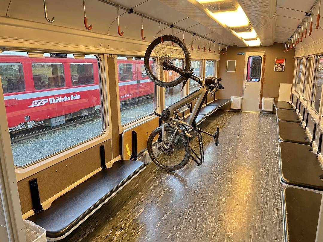
Shuttle, Gepäck
Folgende deutschsprachige Anbieter organisieren einen Rücktransport vom Gardasee und auf Anfrage ggf. einen individuellen Gepäcktransport entlang der Strecke der Albrecht-Route:
- www.bikeshuttle.it: mit Sitz in Südtirol – Tel: 0039-320-3114552
- www.bikeshuttle.at: mit Sitz in Nauders am Reschenpass, TRANSALP-HOTLINE: 0043-664-1217050
Ein besonders toller Service wird hier angeboten.
PKW-Überführung vom Start- zum Zielort: www.transalp-shuttle.com Tel: 0043-676-6877008
Das klappt bestens, wie ich selber mehrfach erleben durfte. Rechtzeitige Anmeldung ist sinnvoll, in der Sommersaison sind sie schnell ausgebucht.
Außerdem gibt es direkt vor Ort in Torbole folgenden Anbieter:
- Shuttle Express Andre Conti (spricht sehr gut deutsch) – Kleinbus für 8 Personen mit Klimaanlage, auch Transalpshuttle.
Sitz: Torbole sul Garda – Tel.: +39 329 1635392
Vorsicht bei preisgünstigen Shuttleanbietern!
Man sollte sich im Vorfeld über die Modalitäten, Fahrzeuge und Ziele erkundigen.

Siehe hier auf dieser separaten Seite.
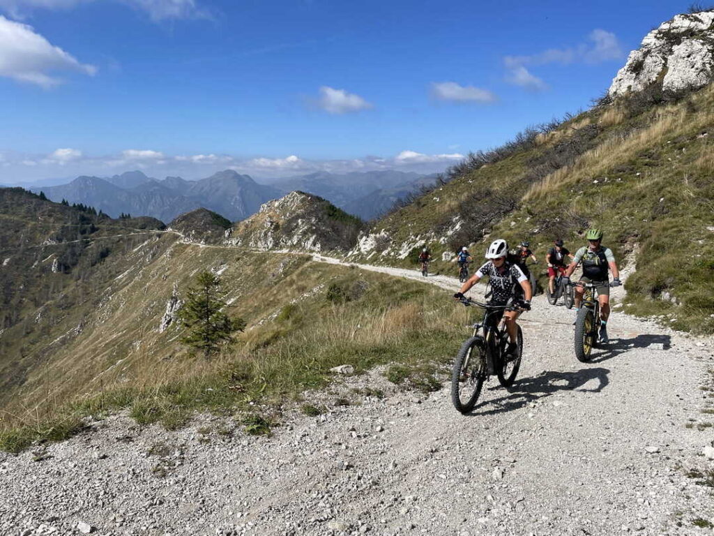
Die Albrecht-Route hat sich zum Dauerbrenner in der Transalpszene entwickelt. Aus vielen Rückmeldungen weiß ich, dass manche die Route mit ihren verschiedenen Varianten oft mehrfach befahren. Diese „Wiederholungstäter“ erfreuen sich daran, dass die Albrecht-Route erprobt und ausgereift ist. Was liegt also näher, als zusätzliche Möglichkeiten zur Erweiterung der Route vorzustellen? Dazu habe ich intensiv recherchiert und stelle eine XXL-Route vor.
Erweiterungen XXL

Detailliert wird die Albrecht-Route XXL hier präsentiert. Lasst euch inspirieren!